Rebecca Luna Lucena
Email: rebeccaosvaldo@yahoo.com.br
© 2019 Sift Desk Journals. All Rights Reserved
VOLUME: 4 ISSUE: 4
Page No: 691-695
Rebecca Luna Lucena
Email: rebeccaosvaldo@yahoo.com.br
Rebecca Luna Lucena 1, Cristiano Saulo de Morais 1, Aline Soares da Silva 1, Sara Fernandes de Souza 1 , Magda Maria Guilhermino 2
1 Departamento de Geografia do CERES, Universidade Federal do Rio Grande do Norte, Brazil. (DGC/UFRN) (rebeccaosvaldo@yahoo.com.br),
2 Unidade Acadêmica Especializada em Ciências Agrárias, Universidade Federal do Rio Grande do Norte, Brazil. (EAJ/UFRN).
Huajiao Li(babyproud@126.com)
Weijun Luo(luoweijun@vip.gyig.ac.cn)
Valeria Gagiu(valeria.gagiu@bioresurse.ro)
Maria Luiza Franceschi Nicodemo(marialuiza.nicodemo@embrapa.br)
Rebecca Luna Lucena, ANALYSIS OF AIR TEMPERATURE AND HUMIDITY IN THE CAATINGA (SEMI-ARID) AREA OF BRAZIL: CONTRIBUTIONS TO THE RECOVERY, CONSERVATION, AND PRESERVATION OF THE BIOME(2019)Journal of Earth Sciences & Environmental Studies 4(4)p:691-695
The aim of this research was to compare the air temperature and relative humidity conditions at two locations in the same agro-ecological settlement: (1) a spot located in an area of Caatinga being restored using berms made of wood waste and stones, and (2) a spot located in a degraded Caatinga area, both in Brazil’s semi-arid region. The data on air temperature and relative humidity of the air were obtained from two automatic Akso AK170 thermo-hygrometers. Both spots have similar elevations but different vegetation and soil conditions. At spot 1 no temperature above 35°C was observed while at spot 2 seven temperatures above 35°C were recorded. Regarding humidity, spot 1 had 11 records for humidity lower than 30%, while spot 2 had 34 records for the same humidity percentage and in addition to that, two records for humidity below 22%, which was not observed at spot 1. It can therefore be concluded that soil recovery practices in the Caatinga using berms, together with thinning, enrichment, trimming, and cutting, promotes a cooler and more humid microclimate.
Keywords: soil recovery, berms; semi-arid region, Caatinga, Brazil.
The preservation, conservation, and recovery of the Caatinga biome, as well as other biomes, is primordial for maintaining the most diverse forms of life and ecological and climatic balance. Forests absorb and provide water for the surface-atmosphere system and additionally promote soil enrichment and shading, creating a specific microclimate within the environment. When pursued inappropriately, human activities such as agriculture, mining, industry, and urbanization undermine these complex systems, the forest structure, and consequently the microclimatic conditions on a local level.
The Caatinga is the only biome found exclusively in Brazil. Rich in species and endemism, its main characteristics are the irregular volume of precipitation, weak rock decomposition, a predominance of stony and rocky soils, and an intermittent drainage system related to the irregular rainfall patterns (AB SABER, 2003; GUILHERMINO et al, 2015). The Caatinga is situated in the northeast of Brazil and has a semi-arid climate. Mean annual rainfall is 800 mm or less, and its aridity index (AI) is up to 0.50 as calculated by the water balance, which relates rainfall and potential evapotranspiration, while the risk of drought is over 60% (BRASIL MMA, 2007). These conditions prevail in an area of around 970,000 km2 in 1,031 municipalities in the states of Piauí, Ceará, Rio Grande do Norte, Paraíba, Pernambuco, Alagoas, Sergipe, Bahia, and northern Minas Gerais, (Figure 1). The Brazilian semi-arid covers 18% of the Brazilian landmass and 53% of the northeast region of the country. It is inhabited by around 22.6 million people, or 12% of the population (Figure 1).
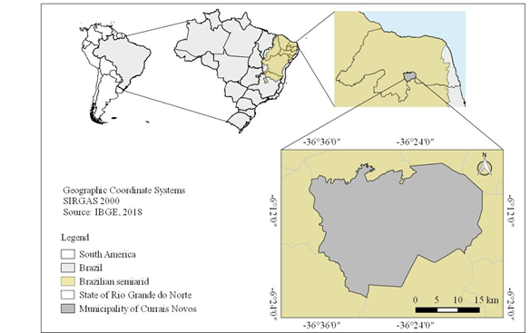
Figure 1. Map of the semi-arid area of Brazil and the municipality of Currais Novos.
According to data from EMBRAPA, the Brazilian agricultural research agency, in around 95% of the Brazilian semi-arid region, the agricultural activities are still dependent on rainfall patterns. The rural population in this region totals some 8.6 million, or 38% of the entire rural population in Brazil (SÁ & SILVA, 2010; BRASIL MDA, 2017).
The aim of this research was to compare the air temperature and relative humidity conditions at two locations in the same agro-ecological settlement: (1) a spot located in a Caatinga area where environmental recuperation is underway (Figure 2) using berms made of wood waste (Figure 3), and stone berms (Figure 4), together with thinning, enrichment, trimming, and cutting; and (2) a spot located in a degraded Caatinga area (figure 5). The settlement is located in the municipality of Currais Novos, in Brazil’s semi-arid region.
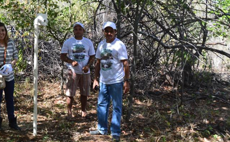
Figure 2. Spot (1) located in a Caatinga area in a recovery process. Source: own research.
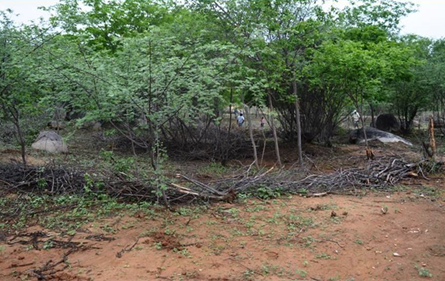
Figure 3. Environmental recovery practices in the Caatinga using vegetation berms, spot (1). Source: own research.
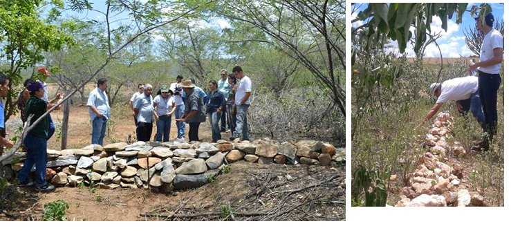
Figure 4. Environmental recovery practices in the Caatinga using stone berms, spot (1). Source: own research.
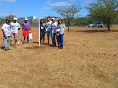
Figure 5. Spot (2) located in a degraded Caatinga area. Source: own research.
Area of interest: Currais Novos and Trangola settlement, Rio Grande do Norte state (Northeast Brazil) – a semi-arid region.
Our study was carried out in the settlement of Trangola, in the typical Caatinga municipality of Currais Novos. It has a hot, semi-arid climate (BSh according to the Köppen climate classification) with high inter-annual rainfall variability and high annual evaporation rates (LUCENA et al, 2013). By applying the proposed climatic water balance (VALADÃO et al, 2010), Curras Novos was found to have a semi-arid mesothermal climate with limited or no water surplus. The rainy season occurs between February and May (3 to 4 months) and total annual precipitation is under 600 mm in years within the historical average. In years of prolonged drought, annual rainfall can fall below 350 mm, as recorded in 2013 (EMATER, 2014). The dry season stretches from June to January (8 to 9 months). According to the United Nations Environmental Programme aridity index (AI), the aridity in Currais Novos is 0.48, or semi-arid with high susceptibility to desertification, since AI values of 0.21 to 0.50 indicate this type of climate (CONTI, 2008). The mean temperatures are between 28ºC and 30ºC and the maximum temperature in the highly degraded areas with severe deforestation reaches 36°C.
-Collection and comparative analysis of data
This research is of an exploratory, descriptive, analytical nature and takes a qualitative-quantitative approach. Two automatic thermo-hygrometers (AK170 dataloggers, AKSO, Brazil, ISSO 9001) were installed (NEVES et al, 2015), which took hourly records (24h/day-1) of air temperature and relative humidity for a 28-day period in the dry season (July-August 2016). The two spots were at similar altitudes (~500 meters) and approximately 400 meters apart. One has scrub vegetation and denser soils spot (1) and the other is located in a very degraded area with sparse herbaceous vegetation spot (2). Spot (1) had been the target of environmental recuperation measures for two years at the time of data collection.
The environmental recovery procedure at site (1) involved the use of berms. A berm (figure 3), is essentially a low barrier made of stones and/or vegetation placed strategically to contain the soil and reduce the speed of runoff on land that was once farmed but is now degraded and/or eroded and in a process of desertification. The vegetation berms are made of leftover cuttings of woody vegetation in the Caatinga. The trees in the area are pruned to remove branches that cause them to lose energy during water shortages, improving their nutrient uptake capacity. The wood waste (figure 4), is piled up to form long berms or placed at the foot of trees to help maintain the humidity of the soil and improve the uptake of organic matter (ARAÚJO et al, 2002; LIRA SANTOS et al, 2007). There are also silt fences, which are built on the beds of water bodies, creeks and streams in micro-watersheds or across rills and gullies in areas with steep slopes (LIRA SANTOS et al, 2007). As such, the aim of monitoring and comparing these two areas served to find out whether the berms and barriers have had any positive impact.
Preliminary results were as follows: spot (1), with scrub vegetation present and more developed soils, had an average temperature that was slightly lower than the one recorded at spot (2), which presents degraded scrub, while the relative humidity of the average air was slightly higher at spot (1) when compared to spot (2). At spot (1) no temperature above 35°C was observed while at spot (2) temperatures above 35°C were recorded seven times. Regarding humidity, spot (1) had 11 records for humidity lower than 30%, while spot (2) had 34 records for the same humidity percentage, plus two records for humidity below 22%, which was not observed at spot (1). Regarding the maximum and minimum temperatures recorded at each spot, the data showed that spot (1) had a maximum and minimum of 34.5ºC and 14.9ºC, respectively, and spot (2) had a maximum and minimum of 36.7ºC and 15.8ºC. For humidity, spot (1) showed a maximum of 91% and minimum of 23.7% and spot (2) had a maximum of 94.4% and a minimum of 20.4% (see Table 1 and Figure 6).
Table 1: Temperature and humidity data were obtained from two automatic thermo-hygrometers. Source: own research.
|
Spots: |
(1) – Recovered Caatinga |
(2) – Degraded Caatinga |
|
Mean Temp |
24.3 oC |
24.6 oC |
|
Max. Absolute Temp. |
34.5 oC |
36.7 oC |
|
Min. Absolute Temp. |
14.9 oC |
15.8 oC |
|
Mean Humidity |
60.2% |
59.2% |
|
Max. Absolute Humidity |
91% |
94.4% |
|
Min. Absolute Humidity |
23.7% |
20.4% |
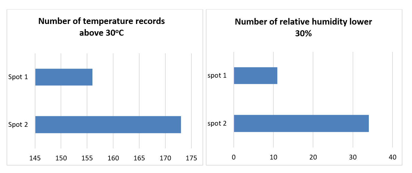
Figure 6. Recorded values of over 30ºC (for air temperature) and under 30% (for relative humidity of the air) at spots (1) regenerated caatinga and (2) degraded caatinga.
Preliminary results confirm the important role that vegetation plays in the local microclimate. Spot (1) showed milder temperatures and higher relative air humidity than spot (2) during the period under study. These results are consistent with several other studies, which have identified the cooling effect of trees in both rural and urban settings (e.g. RIBASKI, 2000, and DOICK & HUTCHINGS, 2013). Rashid et at (2010) and others have also found a strong correlation between changes in air temperature and relative humidity and changes in the local microclimate brought about by tree planting, resulting in a lowering of local temperatures.
In the Brazilian semi-arid, where shallow, stony soil and rocky outcrops are the norm, and even in areas occupied by man where soils that were originally better developed have become poorer and shallower because of extensive grazing and other farming activities (ARAÚJO, 2011), physical containment measures, like berms silt fences, constitute a cheap, sustainable method for accumulating large quantities of sediment and enabling the better infiltration of water, which then serves as the basis for the development of plant cover, making the environment cooler, more humid, and richer in organic matter than areas not treated with such methods.
Spot (1) showed milder temperatures and higher relative air humidity than spot (2) during the period under study. These results are consistent with several other studies, which have identified the cooling effect of soil and trees in both rural and urban settings. It can therefore be concluded that recovery practices in the Caatinga using berms, together with thinning, enrichment, trimming, and cutting, not only retain the soil and encourage the growth of denser vegetation, but also promote a cooler, more humid microclimate in the Brazilian semi-arid region.
AB'SABER, A. N. 2003. "Caatingas: o domínio dos sertões secos". In Os domínios de natureza no Brasil: Potencialidades paisagísticas. 6ª Ed. 83-100, São Paulo: Ateliê Editorial.
ARAÚJO FILHO, J. A.; CARVALHO, F.C.; GARCIA, R.; SOUSA, R.A. Efeitos da Manipulação da Vegetação Lenhosa sobre a Produção e compartimentalização da Fitomassa Pastável de uma Caatinga Sucessional. R. Bras. Zootec., v.31, n.1, p.11-9, 2002.
View ArticleARAÚJO, S. M. S. de. A região semiárida do Nordeste do Brasil: questões ambientais e possibilidades de uso sustentável dos recursos. Rios Eletrônica - Revista Científica da FASETE. Ano 5 n. 5. Pag 89 - 98. dezembro de 2011.
BRASIL, MMA - Ministério do Meio Ambiente. SANTANA, M. O (Org). Atlas das áreas susceptíveis à desertificação do Brasil. Brasília: Ed: MMA - Ministério do Meio Ambiente, 2007.
BRASIL. MDA (Ministério da Agricultura, Pecuária e Abastecimento). Caatinga: a região mais ruralizada do Brasil. Brasília, DF, MDA, 2017.
CONTI, J. B. O conceito de desertificação. CLIMEP - Climatologia e Estudos da Paisagem, Rio Claro, vol.3, n.2, p. 39-52, jul./dez. 2008.
DOICK, K.; HUTCHINGS, T. Air temperature regulation by urban trees and green infrastructure. Forest Research. February 2013, ISBN: 978-0-85538-878-2. CROWN COPYRIGHT pag 1 - 10.
EMATER - Empresa de Pesquisa Agropecuária do RN - EMPARN Gerência de Meteorologia. Climatologia Rio Grande do Norte. Disponível em: , Acesso em: 10/10/2014
View ArticleGUILHERMINO, M. M.; NASCIMENTO, S. M.; LEMOS, A. E. S. . Defeso da Caatinga: Política pública para o desenvolvimento sustentável da agropecuária familiar e a recuperação do bioma Caatinga. In: VII Simpósio Brasileiro de Agropecuária Sustentável (SIMBRAS)/ IV Congresso internacional de agropecuária sustentável, 2015, Viçosa, MG.
LIRA SANTOS, S.C., DE MEDEIROS, J.F., DE MESQUITA, L.X., DE OLIVEIRA, F. DE A., MARACAJÁ, P.B. Informativo técnico do semi-árido. Grupo verde de agricultura alternativa (GVAA), Tecnologias para contenção de solo e água subterrânea: uma experiência de extensão rural na região do Seridó-RN. Infotecnarido, Mossoró, Rn, Brasil, v.1, n.1, p.13-27, janeiro/março, 2007.
LUCENA, R. L; FERREIRA, A. M. FERREIRA, H. F. P. de A. STEINKE, E. T. Variabilidade climática no município de Caicó/RN: secas e chuvas num arquétipo do clima semiárido do Nordeste brasileiro. CLIMEP - Climatologia e Estudos da Paisagem. Rio Claro, Vol.8. p 25 -47, Jul/Dez, 2013.
NEVES, G. A. R.; MARQUES, J. B.; NOGUEIRA, J. de S.; BIUDES, M. S.; ARRUDA, P. H. Z.; CURADO, L. F. A.; PALÁCIOS, F. da R. Desenvolvimento e Calibração de um Termohigrômetro para uso em Pesquisas de Micrometeorologia, Agrometeorologia e Climatológica. Revista Brasileira de Geografia Física. V 08. N 01. 136-143p. 2015.
RASHID, Z. A.; AL JUNID, S. A. M.; THANI, S. K. S. O. Trees' Cooling Effect on Surrounding Air Temperature Monitoring System: Implementation and Observation. International Journal of Simulation: Systems, Science and Technology. DOI 10.5013/IJSSST.a.15.02.10 pág: 70 - 77. 2010.
RIBASKI, J. Influência da Algaroba. (Prosopis juliflora (sw.) Dc.) Sobre a disponibilidade e qualidade da forragem de capim-búfel (Cenchrus ciliares) na região semi-árida brasileira. (Tese) Pós-Graduação em Engenharia Florestal, UFPR: Curitiba, 2000.
SÁ, I. B.; SILVA, P. C. G. Semiárido brasileiro: pesquisa, desenvolvimento e inovação. Petrolina: EMBRAPA Semiárido, 2010.
VALADÃO, C. E. A; OLIVEIRA, P. T.; SCHMIDT, D. M.; SILVA, B. K. N.; BARRETO N. J.C.; CORREIA FILHO, W. L.F.; JESUS E. S.; LOPO, A.B.; SANTOS A.S.; PINHEIRO, J.U.; MATTOS, A. Classificação climática da microrregião do Seridó/RN. In: XVI Congresso Brasileiro de Meteorologia: Anais... Belém: CBMET, Sociedade Brasileira de Meteorologia, 2010.