John W. Reeder
Email: johnwreeder@gmail.com
© 2019 Sift Desk Journals. All Rights Reserved
VOLUME: 6 ISSUE: 1
Page No: 131-147
John W. Reeder
Email: johnwreeder@gmail.com
John W. Reeder
Terra Research International, 6005 Calle Maggioni, Cannaregio, Venice 30121, Italy; and Southwestern College, School of Science, Technology, Engineering and Mathematics, 900 Otay Lakes Road, Chula Vista, California 91910, U.S.A.
Retired after 30 years from the Anchorage office of the State of Alaska, Department of Natural Resources, Division of Geological and Geophysical Surveys, 3354 College Road, Fairbanks, Alaska, U.S.A.; and retired after 25 years as an adjunct at the University of Alaska Anchorage.
John W. Reeder, Geologic aspects (faults, landslides and volcanic dikes) of the Nateekin River shallow earthquake swarm of 15 June 2020 near Makushin Volcano, Unalaska Island, Alaska, U.S.A. (2022) Journal of Earth Sciences & Environmental Studies 6(1) :131-147
Starting 15 June 2020, a shallow earthquake swarm occurred in the Nateekin River valley just east of Makushin Volcano of Unalaska Island, Alaska, U.S.A. Focal mechanism determinations were made on the larger earthquake events. These correlated with four known fault groups originally recognized during 1980-85 field work in this region. These are (a) numerous N 54° W ± striking normal faults, (b) prominent N 74° W ± striking normal faults, (c) N 50° E ± strike-slip faults, and (d) a N 36° E ± striking reverse faults. These fault groups correlate with known dikes for the region, which suggest magmatic intrusions are associated with this earthquake swarm. These faults reflect a predictable fault structure for a regional maximum horizontal tectonic stress direction of N 54° W ± with a localized spreading rift zone associated with Makushin Volcano that is striking N 74° W ±. This rift zone has a reactivated landslide and numerous nearby small landslides caused by this June/July earthquake swarm. This swarm sheds insight into the faulting, volcanic and geothermal processes of the region.
Key words: Shallow earthquake swarm in a volcanic rift zone; four different seismic focal (fault) mechanisms recognized; associated active faults and landslides observed; related Holocene dikes and volcanic activity; regional maximum horizontal tectonic stress and magmatic processes; extensive geothermal resources.
1.1. Situation
On 15 June 2020 two 4.1 local magnitude (ml) shallow earthquakes occurred within four hours of each other on two different fault types in the upper Nateekin River valley just ESE of Makushin Volcano, Unalaska Island, Alaska, U.S.A. Over 1400 earthquakes followed as a cluster within five months of the first and largest 21:16:48 2020/06/15 UTC 4.19± ml event (Alaska Volcano Observatory {AVO} and Alaska Earthquake Center) with nearly 50% of the earthquakes occurring within the first 48 hours. Focal-fault mechanism determinations for the larger earthquakes of June and one in July done manually by the author fell into four fault types. These fault types appear to correlate with suspected Holocene faults that were recognized by the author in the Nateekin River valley back in 1981 through 1984. In addition, reactivation of an old landslide in the mid Nateekin River valley during the time of this earthquake swarm is positioned at the intersection of two of these observed fault types. This suggests that the earthquake swarm is associated with faults that are actually rupturing the surface. If this is correct, the hypocenter locations are actually shallower than indicated by the seismic data and also the epicenters are further east than indicated by AVO. This paper presents evidence for these observed active faults, observed landslides and suspected magmatic dike-growths as being associated with this Nateekin 2020 earthquake swarm.
1.2. The Original Geologic and Geothermal Investigations
The author identified in detail major geothermal areas on the flanks of Makushin Volcano in 1980 [1, 2] and initiated at that time detailed geologic investigations for the entire northern Unalaska Island. In cooperation with The Alaska Power Authority and their contracted Republic Geothermal Inc., a site originally identified by Reeder [3] for drilling an exploratory geothermal well was implemented, which was labelled ST-1 by Republic Geothermal Inc. This well was drilled during the summer of 1983 to a depth of 593 m where it encountered a large water-dominated reservoir at 195ᴼ C (Figures 1 and 2). The well had flow test performed in 1983 and again in 1984 that indicated a reservoir mass water-equivalent volume of 3.1 km³ [4, 5, 6], which makes it of world class!
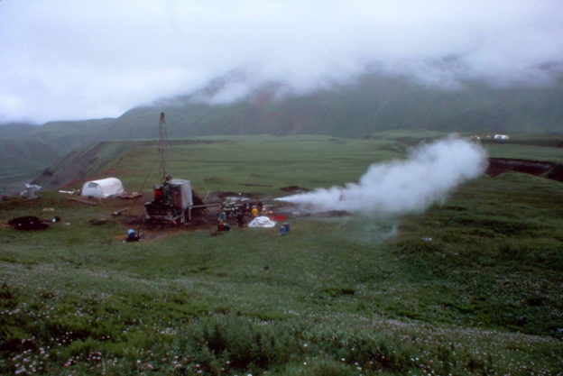
Figure 1. 17 August 1983 view of the initial opening of the Republic Geothermal, Inc. geothermal discovery well ST-1 for its first flow test. The discovery well is located just south of fumarole field no. 1, Figure 2.
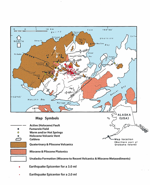
Figure 2. A generalized geologic map of the northern part of Unalaska Island showing suspected active faults, fumarole fields and hot springs, and Holocene volcanic vents. The A to B represents the Ab fault zone of Makushin Volcano. The June 2020 earthquake epicenters great than 1.7 ml are indicated in red.
The ST-1 site was near geothermal field no. 1 (Figure 2) and represents the approximate intersection of two suspected active faults. Both faults appeared to show signs of active faulting. One with an ENE dominantly strike-slip motion is just south of the Makushin Valley and it extends through the fumarole field no. 1 to the west. A similar parallel fault exists just north of the Makushin Valley that extends through the small fumarole field no. 8 and through the Quaternary Sugarloaf volcanic cone. The other significant intersecting "geothermal discovery well" fault strikes N 54° W with a 55° dip to the SW (Figure 3). This fault cuts across a more steeply dipping basaltic dike with nearly the same strike. It has a meter high scarp as shown on a previously glaciated ridge, which is why the author considered it to be an active fault and possibly a prime indicator for determining a geothermal drill site. It was later called the Geothermal Discovery Well Fault. The actual age of the dike that was cut is unknown (rock samples of the dike are at the Alaska Geologic Materials Center, labelled UN-42-R-82). Again, a similar parallel fault was recognized extending into fumarole field no. 8 and the Sugarloaf cone (Figure 2), which suggest a regional repeating structural pattern.
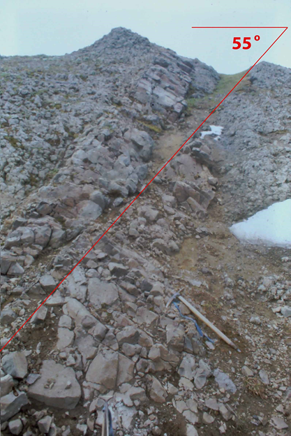
Figure 3. The Geothermal Discovery Well Fault that strikes N 54ᴼ W and dips 55ᴼ SW as a normal fault. It indicates a 6.6 m total dip offset of the near parallel basalt dike with a 1 m scarp shown on the glaciated ridge. The basaltic dike is about 1 meter thick. The location of this 8 August 1982 looking NW view is indicated in Figure 4.
Recognized active faults throughout the northern part of Unalaska Island were identified from 1980 through 1985 as summarized in Figure 2. Drafts of these detailed maps are all at the Alaska Geologic Materials Center along with all corresponding rock samples and related data. Republic Geothermal Inc. freely used these early drafts for their 1983 project report to the Alaska Power Authority (State of Alaska contract CC-08-2334).
The identification of active faults would be particularly important for locating any possible hydrothermal system in any dynamic volcanic and tectonic terrain. Such hydrothermal systems if they exist would have a short life unless fracturing is actively occurring to keep such systems from sealing into non-existence [7]. The ST-1 hydrothermal discovery well was located on the intersection of two suspected active Holocene faults. This well tapped into an incredibly large 200ᴼ C 13 km³ water-dominated hydrothermal system. My original and simplest interpretation for the location of such a large reservoir was within the Makushin caldera complex itself, which is strongly supported by complete Bouguer gravity data for the region [6, 8]. The top of the Makushin Volcano caldera for example has a complete Bouguer gravity of only 88.6 milligals. The ST-1 site has a 138.2 milligals high, which is in general high for the immediate region.
The fracturing of bedrock is extensive throughout the region [9] and such crust could contain other large reservoirs as well. This is also suggested by the gravity data. For example, the second lowest complete Bouguer depression similar to the Makushin Volcano caldera occurs in the upper Nateekin River valley with a 109.2 milligals depression low (Figure 4). This gravity anomaly low extends with a SW axis orientation into the mountainous region to the south. It might reflect an ancient highly fractured volcanic caldera that could contain a major hydrothermal system. The area is S 55° E of the Makushin caldera summit by only 10 km. Shallow seismic activity occurs at this low gravity anomaly (AVO catalog) [10]. In addition, numerous shallow crustal magmatic heat sources are also suspected based on regional crustal uplifts just east of the eastern flank of Makushin Volcano [11] in the region of the ST-1 geothermal well. Shallow seismic earthquake activity and seismic tomography data for the region ESE of Makushin Volcano extend through much of the Nateekin River basin. They indicate possible shallow (7 km) regional magmatic heat sources [12, 13], which includes most of the Nateekin drainage basin. But, based on extensive searches during 1980 - 1985 throughout the entire northern Unalaska Island, no surface heat anomalies are known except for the immediate fumarole and hot springs of and on the immediate flanks of Makushin Volcano; that is except for a small far away Summer Bay warm spring just six kms NE of the City of Unalaska (Figure 2) [1, 14, 15].
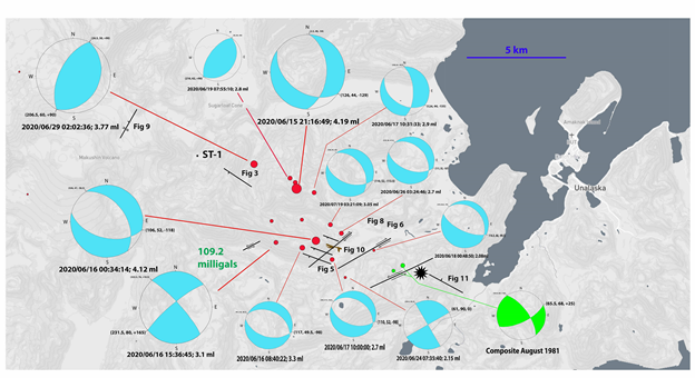
Figure 4. The focal mechanism determinations for the 15 June 2020 through July 2020 Nateekin valley earthquake swarm. Epicenter locations are shown in red. The two largest earthquake epicenters for the 9-16 August 1981 Nateekin valley earthquake are indicated in bright green along with the Composite August 1981 focal mechanism determination. The location of the complete Bouguer anomaly low is shown just south of the upper Nateekin River basin. Only actual Holocene faults observed that relate to seismic data are shown. Numerous dikes and active faults were observed. The location of the Nateekin volcanic dome (yellow asterisk), the mid Nateekin valley 2020 reactivated landslide the ST-1 discovery well is also shown.
With the Alaska Power Authority accepting the ST-1 proposed drill site and then its eventual success, my 1981 and 1982 geologic mapping was extended into the upper and middle Nateekin River valley in 1983 and 1984. The prominent Point Kadin NNW striking Holocene rift zone on the WNW flank of Makushin Volcano had been well established by Drewes et al. [1]. My work established an A to B extension of this rift zone (see Figure 2) as principally a N 74° W zone of normal steeply dipping faults and corresponding dike, which extended from fumarole 2 on the east flank of Makushin Volcano to the head of Captains Bay only 8 km SE of the City Unalaska. This A to B fault zone, called here the Ab fault zone is masked by extensive bedrock alteration of the Unalaska Formation that is exposed throughout much of the Nateekin River valley. This alteration is to the extent that faults were principally recognized by offsets of dikes and sills found within this Unalaska Formation. In fact, the lack of identified faults in the main geothermal fields by others [16, 17] could be explained by this extensive extreme alteration of bedrock as well as by the lack of detailed regional geologic investigations.
2. THE 2020 NATEEKIN RIVER VALLEY EARTHQUAKE SWARM
2.1. The earthquake swarm
The June 2020 epicenters for the Nateekin valley earthquake swarm are shown in red in Figure 2 for the 1.7 ml (Richter local magnitude) events and larger as based on epicenters determined by the AVO. A fairly dense seismic network (8 seismograph stations in the northeastern Unalaska Island region) was used along with other more regional NOAA and USGS stations. These AVO stations were calibrated for the Makushin Volcano region in contrast to the more regional crustal models used by the Alaska Earthquake Center (Univ. Alaska Fairbanks), National Earthquake Information Center (USGS) and Pacific Tsunami Warning Center (NOAA). The AVO epicenter results appear to correlate more with my observed faults than does the Alaska Earthquake Center epicenters. Both epicenter data sets appear to cluster more toward Makushin Volcano region than what my field data indicates should have been the case. For the purpose of this report, I used the AVO data furnished by John Power (of U. S. Geological Survey; personal communication, April 2021) as the more accurate epicenter data set.
2.2. Focal (fault) mechanism determinations
Focal (fault) mechanism determinations for earthquakes principally larger than 2.7 ml were determined by hand for the June and July earthquake swarm. The results are shown in Figure 4. I used Lahr [18] and Klein [19] to interpret the AVO data base. Epicenters of lower ml were not usually considered trustworthy due to the lack of consistent focal mechanism results. This limitation might be due to the influence of magmatic dike/sill intrusion being dominated by the smaller earthquakes [13]. But more likely, it was due to the extensive hydrothermal alteration of the crust observed throughout this region. Eleven focal (fault) epicenters were determined for 15 June to the end of June as shown in Figure 4.
Only one focal (fault) mechanism determination was made for the largest event in July; a 3.05 ml on the 19th at 03:21:09. These 12 epicenters are shown in red (Figure 4). They form two clusters, one that is more scattered in the mid Nateekin valley with a rough NW orientation and the other with a much more linear N 62° W ± orientation in the mountainous region just north of the upper Nateekin River valley but south of the Makushin Valley. Of these focal mechanism determinations, the fault planes that actually reflect observed faults in the immediate area are indicated by the larger print on the lower focal-sphere projections.
In addition, an interesting earthquake composite focal mechanism determination is included in Figure 4 [20] for an August 1981 earthquake cluster that occurred just east of the 2020 earthquake cluster. These 1981 events are indicated in green for the larger two events; 2.4 and 2.6 ml (Figure 4). They fall on a prominent N 65° E left-lateral strike-slip fault that is discussed in the latter part of Section 3.4.
Other shallow earthquakes and earthquake swarms have been detected in this region between 1996 to present (AVO catalog) [12, 13, 21, 22]. They are of interest especially given the number of faults and dikes recognized throughout the Nateekin drainage as well as throughout the NE region of Unalaska Island [9]. But this interesting data is beyond the immediate scope of this report.
2.3. The four focal (fault) mechanism types recognized
Four types of focal (fault) mechanism groups for the June and July 2020 earthquake swarm were recognized. These groups include: (a) a N 54ᴼ W ± normal fault with a 44° ± dip to the SW with a slight right-lateral component (strike 126, dip 44, rake -129) as represented by the first and largest 4.19 ml at 2020/06/15 21:16:49 UTC; (b) a N 74ᴼ W ± normal fault with a steep dip to the south and a very slight right-lateral component (strike 106, dip 52, rake -118) as represented by the second largest 4.12 ml at 2020/06/16 00:34:14; (c) a N 51.5° E ± right-lateral strike-slip (strike 231.5, dip 80, rake +165) as represented by the largest 3.1 ml right-lateral at 2020/06/16 15:36:45; and (d) a reverse fault striking N 36ᴼ E ± with a dip 60° NW ± (strike 216.5, dipping 62, rake +90) as represented by the largest 3.77 ml reverse at 2020/06/29 02:02:36. There are also different faults involved within each group that were roughly parallel to each other, which is supported by field data. Collectively, these all caused the June/ July Nateekin valley earthquake swarm.
The second (b) group, the steeply S dipping N 74ᴼ W ± striking normal fault group, is the most common earthquake type. Yet this (b) group produced only the second largest earthquake, a 4.12 ml just 3 hours 17.4 minutes after the largest 4.19 ml of the first group, the (a) group. This second (b) group dominates the mid to upper Nateekin valley earthquake cluster and is also observed in the more NW cluster (Figure 4). The first group only occurred in the NW cluster and appears to be an actual fault "off-shoot" from the Point Kadin - Ab N 74° W ± striking Makushin Volcano rift zone (Figure 2). The largest strike-slip fault, the 3.1 ml at 2020/06/16 15:36:45, appears to be separating these two clusters. The largest reverse fault, the 3.77 ml at 2020/06/29 02:02:36, then represents the NW limit of the NW cluster.
3. FAULTS RECOGNIZED IN THE FIELD
3.1. The faults
Numerous basaltic and andesitic dikes and cross-cutting faults of numerous orientations were observed in the northern Unalaska Island region [9]. Of prime importance, all four of these 2020 fault groups were observed back in 1980-1985 and at that time were suspected to be active. Active faults were even observed in the Nateekin valley that appear to relate directly to the 2020 June/July Nateekin earthquake swarm. In addition an active strike-slip fault was also mapped that related directly to an earlier 1981 August 6-11 Nateekin valley earthquake swarm detected by the Lamont Observatory Seismic network [20]. These are all indicated in Figure 4.
3.2. The N 54° W ± normal fault group
Of the first group, the N 54ᴼ W ± striking normal fault dipping 55° ± SW (Figure 3 and 4) is the fault used to locate the ST-1 geothermal discovery well. The 4.19 ml of this first group is located just to the east behind this view of the Geothermal Discovery Well Fault (Figure 4). This 4.19 ml event had a hypocenter depth of about 8.6 km (AVO catalog). Given the extensive alteration of the bedrock of this region, the velocity model used by AVO could be off for earthquake events for this region. This could easily effect epicenter locations and especially hypocenter depths. The actual hypocenter depth could be much less and the associated fault could be easily breaking the ground surface. I strongly suspect this fault was involved in generating the 4.19 event. If not, it was caused by a similar parallel fault.
3.3. The N 74° W ± group
The most common focal (fault) mechanism group was the N 74° W ± group having a steep dip to the SW. The first fault of this group observed in the Nateekin valley was mid valley in July 1982 as shown in Figure 5. The terrain is very rough and steep with the fault being exposed in an eroded ravine as shown. The normal fault was striking N 70ᴼ W with a steep dip to the S. A basaltic sill was offset by at least 5 vertical meters. The fault was at the time suspected to be active although no fault scarp was detected above the ravine. During this 1982 reconnaissance, three parallel N 70° W ± steeply dipping normal faults were recognized, which are indicated on the amazing aerial (drone) view of Figure 6 taken by Andy Dietrick in November 2019 (Aleutian Aerial LLC).
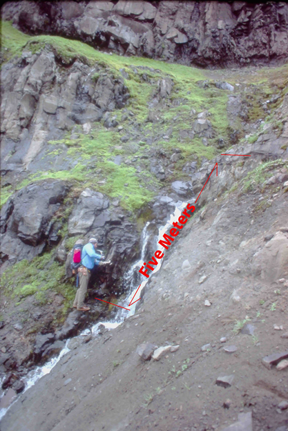
Figure 5. 1 August 1983 view of the N 70ᴼ W striking normal fault dipping 76ᴼ S on the eastern ravine exposure in mid Nateekin River valley just 1 km SW from the head scarp of the 2020 landslide, Figure 4 and 6. Geologist Kirk Swanson taking a sample of the basaltic sill that has been displaced by at least 5 vertical meters.
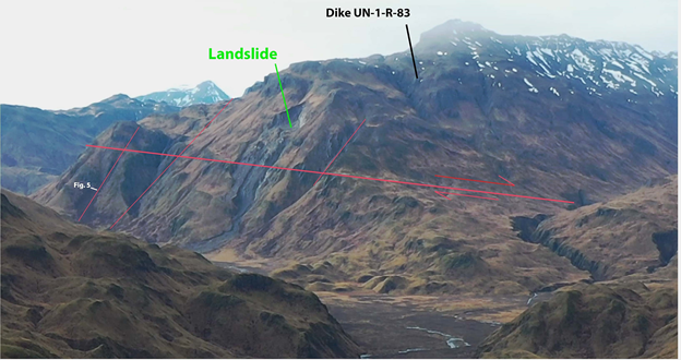
Figure 6. Early November 2019 drone view by Andy Dietrick of Unalaska (Aleutian Aerial LLC) looking WSW of the mid Nateekin River valley of an old landslide in the middle of the view. Active faults shown on Figure 2 and 4 that were discussed in this report are shown in red. The location of Figure 5 is located at a steeply S dipping N 70ᴼ W normal fault outlined by the steep red line to the far left.
3.4. The N 50ᴼ E ± strike-slip fault group
One of the most obviously active strike-slip faults of the region, similar to the N 50ᴼ E strike-slip focal (fault) mechanism determined for the Nateekin valley, was observed in the Portage Bay and Captains Bay pass just south of the Shaisnikof River drainage. Actual ground breakage was observed on this and on the corresponding intersecting N 80° E right-lateral strike-slip fault (Figures 2 and 7). This is a very steeply dipping to the NW left-lateral strike-slip fault striking N 50ᴼ E with a slight reverse component. This fault extends through the pass and also appears to extend along the south side of Captains Bay. It has been mapped across Unalaska Valley and then to the south edge of Summer Bay Lake near the Summer Bay warm spring [15]. Just the existence of a warm spring suggests this fault might be active. The regional extent of this fault suggests it is tectonic in nature. It would fit into the interesting strike-slip zone of the arc [23, 24].
A prominent N 51ᴼ E strike-slip fault was also recognized in this mid Nateekin valley area recognized by small offsets of nearly vertical dikes. It was recognized initially on the steep south facing slope just south and out of view of the Figure 5 fault exposure that is indicated on Figure 6. The fault is a right lateral strike-slip and would fit into the right-lateral N 50° E ± focal (fault) mechanism group. It cuts through the large Nateekin landslide and has an observed steep dip of 80ᴼ NW with a small reverse component (rake +165). The N 51.5ᴼ E focal mechanism fault of 2020/06/16 15:36:45 had a 3.1 ml (Figure 4) and a hypocenter depth of 8.27 km. The epicenter of this 3.1 ml event is just 2 km west of this fault (Figure 4). Again given the extensive hydrothermal alteration of the Unalaska Formation throughout this region as shown for example in the head scarp of the Nateekin landslide, the travel times of earthquake waves can vary extensively. As a result, epicenter locations would be expected to be off and depth control even more so. Having localized landslides at/near this strike-slip fault strongly increases the geologic argument that it probably is the cause of the 2020/06/16 15:36:45 event (See Section 4).
Of interest, other additional strike-slip faults were identified (as shown in Figure 4) in the mid Nateekin valley just upstream and downstream of the Figure 6 faults and landslide. These have slightly different strikes and even unexpected motions. There is an immediate strike-slip right-lateral fault just across the Nateekin River to the east from Figure 6 that strikes N 60° E with an 85ᴼ NW dip with a slight reverse component (Figures 4 and 8). The 2020/06/24 07:35:40 2.15 ml event occurred just east of this N 60° E fault at a depth of 8.5 km. Its focal (fault) mechanism has a N 61ᴼ E right-lateral strike, vertical dip and 0 rake. Determinations of focal mechanisms for such small magnitude earthquakes involves weaker seismic signals and therefore poorer first P-wave polarity direction determinations. But this event was of prime location and interest. A focal mechanism determination was attempted and fortunately was achievable with fair confidence. But most likely the dip is not exactly vertical and the rake is not exactly 0 and should be a small plus value.
The other downstream observed strike-slip fault is further east. It has a N 65° E strike with a 70ᴼ SE dip with again a slight reverse component (Figures 4 and 8). This possibly reflects a more perpendicular true maximum horizontal tectonic stress direction of N 45° W that was originally identified by Nakamura for the region [23, 24]. This could be due to a more rigid crust because of the lack of significant shallow magma bodies in this immediate area. This fault was observed to be a left-lateral fault. The Nateekin 2020 earthquake swarm did not involve this type of fault motion. But a 6-11 August 1981 earthquake swarm observed by the Lamont Observatory seismic network [20] does have this motion and these 1981 epicenters located on the fault. The epicenter locations of the two larger events of this 1981 swarm are shown as bright green in Figure 4. These larger events were a 2.4 ml at a depth of 4.6 km and then a 2.6 ml at a depth of only 0.5 km. The composite focal (fault) mechanism determination for the entire swarm had a strike of N 65.5° E with a 68ᴼ SE dip and a rake of +155° (Figure 4). This would be a left lateral N 65.5ᴼ E strike-slip fault with a 68° SE dip with a slight reverse component. Left-lateral movement of this fault is probably the cause of the 6-11 August 1981 Nateekin shallow earthquake swarm. The left-lateral movement might be due to nearby NW oriented dike growth.
Another left-lateral strike-slip fault was observed about 5 km along the main Nateekin River upstream from the reactivated landslide (Figures 4 and 6) and is located just east of the actual epicenter location of the 2020/06/16 15:36:45 right-lateral strike-slip 3.1 ml event. The fault is not only well exposed on the north bank of the Nateekin River but actually appears to have offset the river channel by about 10 meters left-laterally. In general, the river also has a WSW trend upstream of the fault for at least a km where at the fault it abruptly changes to this WSW trend. Of possible importance, this fault is well recognized to extend to the SW on air photographs and it trends into the large complete Bouguer gravity low anomaly of 109.2 milligals (Figure 4). Again, maybe this left-lateral motion is due to extensive ongoing NW oriented dike growth near the Makushin Volcano.
3.5. The N 36° E ± reverse fault group
One of the best exposures of a reverse fault similar to the reverse (fault) mechanism group determined for the Nateekin River valley was observed on the NNE flank of Makushin Volcano (Figure 9) with locations shown on Figures 2 and 4. This reverse fault strikes N 27° E ± with a dip of 60ᴼ ± NW. It has a displacement of over 8 meters vertical. Because this fault appears to extend into Makushin caldera, it was considered active. It also appears to extend further SSW to the active fumarole field no. 5 on the southern flank of Makushin Volcano, Figure 2. This fumarole also suggests the fault is active. Numerous similar N 36° E ± reverse faults were mapped and/or based on linear land features [25] on the eastern through southern region of Makushin Volcano as well as in the Nateekin River valley. The observed faults near Makushin Volcano extended from the southern Reese Bay through the fumarole areas 8, 1, 2 and 3 as well as down through Glacier Valley (also called Makushin Bay valley). Unfortunately, the extensive hydrothermal alteration of the bedrock helps prevent the recognition of most faults in this region (Figure 2) [9]. They are perpendicular to the recognized N 55ᴼ W ± maximum horizontal tectonic stress direction [24] whereas the N 27° E ± fault is more perpendicular to the Point Kadin rift zone of Makushin Volcano.
3.6. Other active fault types not associated with the Nateekin 2020 earthquake swarm
The Figure 7 site is an active fault striking N 80ᴼ E with a 78ᴼ S dip. This interesting right-lateral strike slip fault with a reverse component does not fit into any of the recognized 2020 Nateekin shallow earthquake swarm groups. But this type was detected by focal mechanism determinations of several earthquakes in the upper Nateekin Valley by McNutt and Sanchez [21] between 1 August 1996 and 30 Sept 1998. I never recognized this group of faults in the Nateekin Valley during my 1980s field investigations, which may indicate my field work is still incomplete. But this type coincides with the ENE parallel fault that intersects the Geothermal Discovery Well Fault at ST-1 and at fumarole field no. 1 (Figures 2, 3 and 4). This fault type did not generate earthquakes at the time of the 2020 Nateekin earthquake swarm. It has had definite Holocene activity by showing disrupted soils and vegetation along its surface with a minor scarp of tens of cm on its upside (to south). Again, this is one of the main reasons I selected the ST-1 site because it was the intersection of two suspected Holocene faults; this type and one amongst the N 54° W± group. It also points to the important fact that numerous active faults exist in this region that are not included in the four groups recognized in the 2020 earthquake swarm.
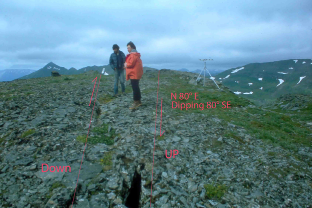
Figure 7. Geologist David Edge and resident Abi Woodbridge on the active N 80ᴼ E striking right-lateral strike-slip fault at the Captains Bay to Portage Bay pass on 18 August 1982. This location (Figure 2) is at the USR short period vertical seismograph station operated by Lamont Observatory (Jacob and Boyd, 1985).
4. LANDSLIDES
4.1. A large reactivated landslide at the time of the 2020 earthquake cluster
The old reactivated landslide indicated on Figure 6 does appear on old U. S. National Archives air photographs dated 26 September 1950 (U. S. Geological Survey). The landslide on these old air photographs is smaller although its head scarp region was unfortunately partly covered with clouds. In its toe region it was definitely inactive where the old photographs had a healthy cover of grass/ vegetation. In 1982, I walked both the head scarp and base regions of this old landslide looking for faults and hot spots. At that time it was not active with the toe being extensively covered with vegetation and the head scarp indicating no recent exposed soil (unconsolidated materials). The observed strike-slip fault of 1982 crosses above the narrow neck of the main body of the landslide with this fault well below the main head scarp (Figure 6). I suspected another N 70ᴼ W ± fault in the main ravine of this landslide, but I had difficulty getting to all parts of this slide and did not detect such a fault.
The Lamont Observatory earthquake swarm located just to the ESE on August 6-11, 1981, did not reactivate this old landslide. The landslide also showed no sign of reactivation on air photographs obtain on 1 August 1982 by Northern Aerial Surveys Inc. for the State of Alaska as part of my State of Alaska geothermal project. The Nov. 2019 view by Andy Dietrick does suggest some reactivation had begun in the past due to the lack of any significant bare soil and dead vegetation, therefore the time of this reactivation must have been at least several years before November 2019. Small earthquakes have been known to be fairly common in the Nateekin River valley since 1996 (AVO catalog) [12, 13, 22]. In fact several NE or NW strike-slip focal mechanisms were first determined for shallow earthquakes in the upper Nateekin River valley between August 1996 and September 1998 [21] with a prominent composite N 70° E strike-slip component along with numerous other shallow earthquakes in the region. The
November 2019 view of the landslide does indicate the head scarp has enlarged since the time of my 1982-84 visits, which most likely occurred sometime between 1985 and 2018. The just mentioned numerous earthquakes during this time period could have enlarged this landslide. But the views captured by recent aerial (Figure 10(a); Google "2019 and more recent" (i.e., summer 2020)) indicates significant enlargement of the upper head scarp, pronounced downward movement of the main body at the strike-slip fault location and with extensive debris accumulation in the toe region that actually reached the Nateekin River at its SE toe. This recent reactivation looks very recent given all of the bare soil and debris lobes in the lower part of the slide. The google photographs would predate the late fall of 2020 and I suspect such movement did occur during the main 2020 Nateekin earthquake swarm of June. But no documented exact date of this significant landslide event exists. The Figure 10(b) aerial view (mid-summer 2021) indicates the 2020 displaced vegetation has died and the slide had been extensively eroded at its SE toe by the Nateekin River. Debris is still being carried to this toe by fluvial as well as alluvial processes. The large NE toe appears to have enlarged only slightly if at all. This NE toe might still reach the river in the near future, especially if the main body of the landslides below the head scarp comes down.
4.2. New smaller landslides at the time of the 2020 earthquake cluster
Of significance, other smaller landslides occurred and appear to be all fairly fresh on the recent satellite image from Google (Figure 10a). These smaller landslides all occurred to the east (downstream) of this large landslide of Figure 6. They occur on both sides of the Nateekin River on only the steep ravine slopes. For example, some of the larger of these appear in the upper northern view of Figure 10(a). These small slides are no longer fresh in appearance in Figure 10(b). The fact they all occur in the mid Nateekin Valley suggest they are related to the same local cause, i.e., earthquake and/or weather. But thunderstorms are rare in this region and rainfalls are usually very regional. Therefore a local earthquake would be the most likely cause.
4.3. Active faults and landslide association
With all of the Holocene fault scarps in this region, extensive landslides associated with faults and earthquakes should not be a surprise. Dave Keefer of the U. S. Geological Survey in Menlo Park for example has been studying earthquake caused landslides most of his life [26] and has even documented many such landslides for Alaska. Active faults play a key role in controlling the location of active landslides [27]. In my own studies of geothermal resources, I use landslides and linear fault scarps as a tool for identifying active faults [28]. The recognition of such faults and especially their intersection in an active volcanic region is a powerful tool for identifying geothermal targets. That is exactly what I did to determine the ST-1 site in 1981/82 for Unalaska Island, which fortunately Republic Geothermal Inc. and the Alaska Power Authority agreed to use as their drill site. Just the existence of this large mid Nateekin Valley reactivated landslide at the vicinity of my 1982/83 suspected active faults only raises a "red flag" for the involvement of the recent June and July 2020 Nateekin earthquake swarm.
5. NATEEKIN DIKES AND VOLCANIC DOME
5.1. The Nateekin dome and associated flows
Of interest, the N 65.5° E left-lateral strike-slip fault (Section 3.4) is just WNW of a large unglaciated Holocene volcanic dome/vent with associated flows that were originally described by Drewes et al. [1]. This dome has several lava flows with the largest extending down to the floor of the Nateekin valley (Figure 8). The fault appears to actually dip into this vent at depth! The dome consists dominantly of basalt. U-2-R-82 is a representative large sample collected on 1 Aug 1982 at the very top of this dome, which is at the Alaska Geologic Materials Center. Although extensive and often large aplitic quartz-rich xenoliths occurred in this dome, they are not part of this U-2-R-82 sample. No isotope age date has been attempted for this sample. The dome is unglaciated and has several associated lava flows of different relative ages. The most recent flows are the smaller that flowed almost directly west. Based on the lack of significant erosion of their toes by mountain streams, they are probably mid-Holocene (about 4,000 years before present). But the main unglaciated flow is the one that extended down the entire mountain slope to the Nateekin valley bottom. Its western side has been eroded by a highly active mountain stream. The resulting eroded steep slopes of this flow appear to be very stable and very resistant to erosion. I would estimate roughly that at least 8,000 years would have been required to have eroded the resulting canyon (i.e., most of the Holocene). No erosional degradation curves have been established for volcanic flow surfaces for this region and it is questionable whether such attempts would be feasible [29]. My estimates are probably as good as one can determine. A previous flow that appears associated with the Nateekin dome crossed the entire Nateekin Valley floor to its north side. This pre-Holocene flow has been extensively glaciated and has been mostly eroded away.
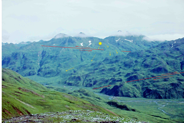
Figure 8. View of the Nateekin dome (yellow star) and associated flows (yellow arrows) looking SE across the Nateekin River valley from the opposite valley side by John Reeder on 2 August 1983. The recognized lower right-lateral strike-slip (N 60° E with an 85ᴼ NW dip) fault is indicated in red. The upper recognized near dome left-lateral strike-slip (N 65° E strike with a 70ᴼ SE dip) fault is indicated also in red.
It has been claimed this dome and associated flows are actually just a large rock glacier and thus it is not even a volcanic vent [17]. This was based, as they stated, on just air photographs and apparently, they never visited the Nateekin Valley even though it contains one of the most important rift zones of Makushin Volcano. But the region of this Holocene vent has had shallow seismic activity (AVO catalog) [20] and extensive dike swarms are exposed on its south and east sides. It also consists of a slightly el. ted dome that makes it difficult for any talus and/or landslide material to deposit directly onto its top especially since nearby ridges are not that much higher. But enough altered inclusions/xenoliths exist in the lava flows to possibly allow some movements downslope with time. But no such movements were observed on its fluvial eroded sides. In fact, I would argue that no such movements have occurred for eight thousand years! The older and main eastern flow (Figure 8, eastern yellow arrows) still preserved its main lava flow block-falls and pull-away crevasses in its main upper channel. Ash falls in this region during the Holocene have not been enough to fill these crevasses.
5.2. Dike swarm striking N 55ᴼ W ± with a steep NE dip
The dome is positioned on a major dominantly NW oriented dike swarm with a few Quaternary dikes being present as based on the lack of any significant alteration. These dike swarms extend SE into the head region of Captains Bay (point B in Figure 2) with a general dominant strike of N 55ᴼ W which includes a surprising steep NE dip (Figure 11). NNW striking faults that steeply dip NE also exist and are fairly plentiful cutting across many of the dikes. These dikes were not found to extend into the Captains Bay Pluton [1], which is immediately SE of the Shaisnikof River. Possibly these dikes were cut off by the strike-slip fault (Figure 2). The dominant N 55ᴼ W ± strike of the dikes suggests a fairy rigid crust that would reflect the direction of regional maximum horizontal tectonic stress [24]. Therefore, any large magma bodies would be at a depth of at least 7 km. Yet, the existence of the dome is evidence itself of some very shallow magma during the Holocene.
5.3. Vertical dikes striking N 55ᴼ W ±
Downstream of the Nateekin River just below the Nateekin dome, numerous vertical dikes are well exposed along the southern and eastern river banks and nearby steep mountain slopes. They number over a hundred with somewhat parallel faults occurring as well. They occupy the region between the N 65ᴼ E left-lateral strike-slip fault near the Nateekin dome and the N 60° E right-lateral strike-slip fault just east across the Nateekin River from the Nateekin landslide (Figures 4, 6 and 8). The strike-slip faults appear to reflect an offset in spreading magma bulges/ridges in a fairly rigid crust in the northeastern Unalaska Island region. In this particular area of vertical dikes, the magma body would have been directly beneath and most of the intruding dikes took on a principally vertical N 55° W orientation. This would be the direction of expected maximum horizontal tectonic stress [24, 31].
5.4. Dikes striking N 55ᴼ W ± with a steep SW dip
Most of the dikes observed in the upper Nateekin River drainage fall into the N 55° W ± dike group usually with a steep SW dip. They were quite common just upstream of the Nateekin landslide toe of Figure 8 and were a major influence on the direction of stream flow in this somewhat rugged Nateekin canyon area before reaching the toe of the recent landslide. But one of the most significant N 55ᴼ W ± striking dikes in the upper Nateekin valley is the SW dipping one (Figure 3) that was cut by the N 54ᴼ W striking Geothermal Discovery Well Fault (Figure 4). But dike swarms of the N 55ᴼ W ± group in the upper Nateekin valley are less common and do not even compare to the impressive vertical dike swarms downstream of the Nateekin valley dome and associated flows and to the NE steeply dipping dike swarms east of the Nateekin dome toward the Captains Bay (Figure 11; Site B on Figure 2). Far NW of Nateekin valley, a nice N 55ᴼ W striking basaltic dike dipping to the NE can be seen on the northern flank of Makushin Volcano (Figure 9).
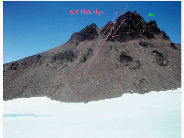
Figure 9. Active reverse fault striking N 27° E with a dip of 70ᴼ NW just 6 km NNE of Makushin Volcano caldera N ridge on 9 August 1982, Figure 2. Ten meter vertical offset was measured of a Makushin lava flow capping the Unalaska Formation. A basaltic N 55° W striking dike dipping NE is exposed on the down block.
5.5. Second most common but gigantic N 74° W ± dike group
The second most common dike group for this Nateekin valley region is the N 74° W ± [9]. These dikes are fairly common in the heart of the upper and mid Nateekin valley and were rarely observed to the north and less so to the south. One of the largest and most impressive dikes of this group intruded Quaternary Makushin volcanics and is exposed just below the highest peak in the mid Nateekin valley just above the reactivated landslide and above the faults shown in Figure 6. It is indicated in Figure 6 as UN-1-R-83 and at this exposure it has an amazing width of 21 meters. It is an andesitic dike striking N
76° W with a steep 86° NNE dip. It has massive horizontal columnar jointing and a large sample of it (UN-1-R-83) is at the Alaska Geologic Materials Center in Anchorage, Alaska. Of special interest, it is located right at the epicenter of the second largest earthquake of the 2020 swarm; the 4.12 ml
2020/06/16 00:34:14 event (Figure 4). This earthquake had a focal mechanism strike determination of N 74° W (106°, 52°, -118°) and a hypocenter depth of 6.64 km. Its strike is almost identical to that of the observed dike, but the dip is much more gentle to the SW. Both align directly with the general direction of the recognized A to B (Ab) rift zone of this region (Figure 2)!
5.6. Other dike groups recognized
Dikes were also observed in the upper Nateekin River drainage that not only represented (reflected) by strike and dip of all four fault groups recognized in the 2020 earthquake swarm but also by others such as the N 80ᴼ E ± strike-slip group (Section 3.6) [9, 21]. Of the less common dike groups, the N 36° E ± striking reverse (fault) group was more common than the N 50ᴼ E ± striking (fault) group. These N 50ᴼ E ± strike-slip faults appear to mark crustal boundaries between the various dip variations (NE, vertical,SW) for the N 55ᴼ W ± group of faults and dikes. Their strike movement rate and even motion direction probably reflect dike formation rates and locations in the crust next to the given strike-slip faults involved. Just the fact that all recognized fault orientation groups correlate with observed dike orientation groups raises a strong argument that the faulting and diking processes are related. In addition, the fact that N 60ᴼ E ±, N 65ᴼ E ± and even N 80ᴼ E ± strike-slip faults occur (Section 3.4) suggest that the true maximum horizontal tectonic stress direction might not be N 55ᴼ W ± but instead a more N 45ᴼ W ± for the non-magmatic rigid crust of this region, which was a value originally estimated by Nakamura et al. [24].
6. THE "Ab" RIFT (FAULT) ZONE AND ASSOCIATED MAGMA BODIES
The A to B (Ab) fault zone is part of a prominent N 74ᴼ W ± rift zone of Makushin Volcano that extends from the fumarole field no. 2 on the ESE flank of Makushin Volcano, extending ESE across the Nateekin River valley up to the Shaisnikof River valley of Captains Bay (Figure 2). It appears to be an extension of the N 70ᴼ W Holocene Point Kadin volcanic rift zone on the WNW flank of Makushin Volcano [1, 17]. This Ab rift zone is dominated by N 70ᴼ W ± striking normal faults that are mainly steeply dipping SW as the identified (b) cluster of the WNW striking normal fault group of the June 2020 events. These represented all of the normal faulting that was driving the mid Nateekin 2020 earthquake cluster (Figure 4). Such faulting also occurred in the more northern 2020 earthquakes cluster along with numerous normal faults striking N 54° W ± (Figure 3; the 2020 June and July earthquake cluster (a) group). These N 54ᴼ W ± faults appear to be offshoots from the N 74° W ± faults of the main Ab rift zone. They are following the N 54ᴼ W ± direction of maximum horizontal tectonic stress [24].
The magma bodies appear to be very shallow on the east flank region of Makushin Volcano (kms) and extends to the ESE through the Nateekin valley region as based on seismic data [12, 22]. A N 74° W ± oriented bulge would be expected to result above the Ab rift zone. Of prime interest, if extensive magma bodies exist at very shallow depth, the crust above will lose its tectonic-caused N 55ᴼ W ± maximum horizontal stress direction to a more hydrostatic uniform stress field [30] with spreading occurring from the N 74° W ± oriented bulge axis. This is possibly why the N 28° E ± reverse fault is more perpendicular to the Point Kadin (Makushin) rift zone of Section 3.5. At this location it has extensive shallow magma bodies of more hydrostatic uniform stresses. The mid Nateekin valley 2020 earthquake cluster would be directly above similar shallow magma bodies of the Ab rift zone. This rift is spreading from this WNW oriented shallow magma body and reflects a more hydrostatic stress field of shallow and most likely connected magma bodies [30, 31, 32] at least as far southeast along the rift zone to the Nateekin dome. Spreading caused by such a magma bulge would result in an even more active WNW rifting that could result in significant earthquakes (up to 5ml) and eventually even more mafic volcanic eruptions. As fractures extend further away from a shallow magma body, they would reflect more the regional tectonic stress. This helps explain the N 54° W ± regional fractures following the direction of maximum horizontal tectonic stress direction as they are future away from the massive regional N 74ᴼ W ± oriented magma body of the Ab rift zone. This indicates that there is indeed fairly extensive shallow magma in the Ab rift zone, which helps explain the massive 21 m wide U-2-R-82 N 76° W striking dike (Section 5.5; Figure 6). Magma bodies NE and SW of this Ab rift zone would be expected to be smaller. Such smaller magma bodies would have less effect in reducing the regional tectonic crustal stress field to a more hydrostatic one as suspected at the Ab rift zone.
Originally it was interpreted that the N 70ᴼ W rift zone of Makushin Volcano was formed as a N 55ᴼ W ± fracture zone that originally reflected the direction of maximum horizontal tectonic stress. It would have been crustally rotated to its present position [9]. But no geologic data has been so far found to support this model. The simplest explanation for this N 70ᴼ W ± rift zone would be for extensive magma bodies at depth having roughly the same orientation as the resulting rift that is spreading.
Bulging of the Makushin Volcano broad east flank region of up to 7 cm between October 1993 to September 1995 was document [11], which is on this Makushin Volcano Ab ESE rift zone. But right lateral strike-slip dominated during the 2020 earthquake cluster, suggesting differential spreading was indeed occurring during this earthquake cluster. This indicates magma intrusions are occurring at depth contemporaneously with the faulting in this region and they are likely triggering additional movements of the different fault types (groups). Also occurring are significant steeply dipping reverse faulting as represented by the N 36ᴼ E group (Section 3.5). This suggests prior magma uplift followed by immediate down-lift during the recent earthquake swarm as magma flowed and formed dikes. Such suspected bulging and deflation events should be confirmed with tilt meters and/or GPS. Diking would be expected along all of the recognized fault groups during this recent swarm [30, 31, 33] and such dike orientations for the past have indeed been found throughout the northern Unalaska Island [1, 9, 17] that includes the Nateekin River basin.
7. VOLCANIC HAZARDS
The Makushin Volcano does pose a hazard to any geothermal development at or near the ST-1 hydrothermal well [34]. Fortunately, the latest caldera forming event of Makushin Volcano was about 8,500 years ago [35, 36]. The Nateekin River drainage basin is the only major drainage basin in the immediate Makushin Volcano that has a natural mountain barrier protecting it from any future direct pyroclastic blast from this volcano. In fact large Holocene pyroclastic deposit are lacking in the Nateekin River drainage basin. Yet, this basin has been ignored for any geothermal development potential directly within the basin or indirectly from the immediate Makushin Volcano flank region.
The Nateekin valley is dominated by the Ab rift zone that has potential of not only producing localized earthquakes but volcanic eruptions as well (Section 6). But, unlike Makushin Volcano, such eruptions would be more mafic and should not pose the pyroclastic hazards that Makushin Volcano does. Neverthe-less, volcanic risk exists and associated earthquakes could be as large as 6 ml given the regional extent of the rift zone. The risk of lava flows also cannot be ruled out given the existence of the massive U-2-R-82 dike and the Nateekin dome with its associated flows.
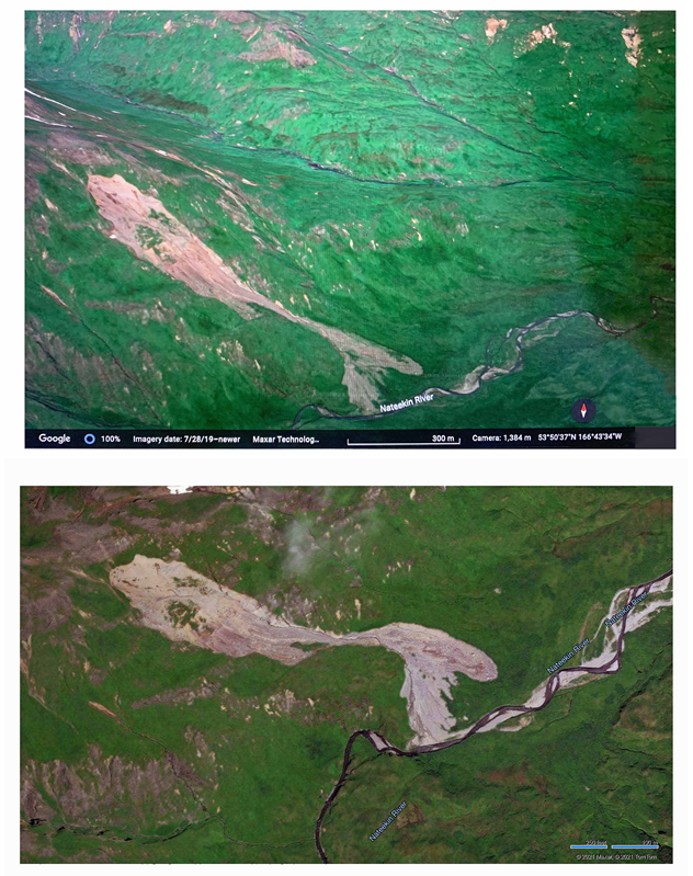
Figure 10.(a) A Google oblique view looking north mid-summer 2020 of the reactivated mid Nateekin River valley landslide. Three other recent landslides can also be seen in the upper right of this view and numerous other small slides were detected in this immediate area downstream. These are all suspected to be directly associated to the June and July 2020 shallow earthquake swarm. (b) A vertical Google view with north being vertical mid-summer 2021 of the reactivated mid Nateekin River valley landslide. The slide appears fairly stable with displaced 2020 vegetation is dead.
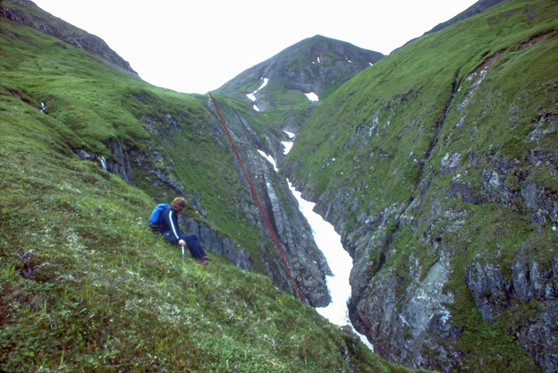
Figure 11. N 55ᴼ W ± striking dike swarm and fault zone that strikes across the ridge top toward the Nateekin volcanic dome (Figure 2). These dikes are steeply dipping to the NE with parallel and near parallel normal faults. A N 57ᴼ W striking fault is shown in red. These faults and dikes are part of the Ab rift zone. This early summer 1984 view looking NW is of student Mark Ripley.
The epicenters and focal (fault) mechanism determinations of the larger June and July 2020 shallow earthquake cluster of the Nateekin River valley correlate with recognized faults of the region and even with landslides. If the field correlations with seismic data are correct, these earthquakes are actually shallower and further to the east from Makushin Volcano than indicate by the AVO catalog. Four groups of faults have been recognized based on these field observations and focal (fault) mechanism determinations for the larger earthquakes for this cluster. This is not representative of a tectonic earthquake that would have dominantly only one type of repeating aftershocks. Instead, this 2020 earthquake cluster was represented by four distinct earthquake group types. These four fault groups are: (a) a N 54ᴼ W ± normal fault with a 44° ± dip to the SW, (b) a N 74ᴼ W ± normal fault with a steep dip to the S, (c) a N 51.5° E ± right-lateral strike-slip, and (d) a reverse fault striking N 36ᴼ E ± dipping 60° ± NW. The earthquakes appear to cluster into two main regions: a mid Nateekin valley cluster that is located on the Ab N 74ᴼ W ± rift zone that is spreading from its WNW axis; and a N 54° W ± splinter from this rift zone that follows more the regional maximum horizontal tectonic stress direction for the region. A right-lateral N 51.5ᴼ E strike-slip fault separates the two epicenter clusters as represented by a 3.1 ml event. This type of fault movement is evident of magma intrusion at different rates at various locations. The largest reverse-fault earthquake of 3.7 ml marks the western boundary of the NW splinter cluster. This group of reverse faults probably repeats at other locations and could represent a significant structural control of the main geothermal fields and even of Makushin Volcano.
There is value in combining field observations with seismic observations. It does appear that magmatic bodies exist beneath the Nateekin River basin as based on geologic and seismic data. The Ab fault zone is dominated by N 74° W ± striking normal faults as represented in this earthquake cluster that likely extends to the Holocene Point Kadin N 70ᴼ W ± rift zone on the NW flank of Makushin Volcano. The NNE reverse fault earthquake that marked the eastern boundary of this 2020 earthquake cluster probably reflects a major down-lift structure following magma loss due to dike growth, which probably mirrors similar structures in the NNE oriented fumarole fields found at the east base of Makushin Volcano and even at the Makushin Volcano summit region. The NE oriented strike-slip faults appear to mark the boundaries of different fault and dike NW oriented types having roughly the same strikes and dips. This field observation possibility reflects magmatic dike growth with time and location within the different crustal sections between these NE oriented strike-slip faults. These strike-slip motions may change rates and even reverse directions depending on the rate and/or location of intrusive dike growth, especially in the active Ab rift zone.
It is hoped that this report sheds some light on the geologic and geothermal processes of the northeastern Unalaska Island, especially since actual geothermal development activity has finally started again. Over 40 years of research on my part are represented in this report, which is only a blink for geologic time. Scientific experts, including even myself, need to realize that there is much more to learn about this active region of Alaska.
Thanks is extended to the Aleutian residents Abi (Ab) Woodbridge, Kathy Grimnes, the Currier family (presently in Anchorage, Cordova and Wasilla), and Agrafina and Scott Kerr among many others who have always given valuable support for my Aleutian research. Thanks is given to my many helpful reviewers, including especially Dr. Thomas T. Mowatt, retired Senior Geologist, U. S. Bureau of Land Management, Alaska District; Daniel L. Rawson, retired past owner of a successful technical science company; Margarita Otero, graduate student at University of Nevada; and Benjamin Currier, an up-and-coming writer in Soldotna, Alaska. I like to pay respect to the late Professor Irwin Remson of The School of Earth Sciences at Stanford University who taught me good research comes with interdisciplinary approaches, persistence, patience and most importantly with innovative ideas. I also greatly appreciate the late Professor Kazuaki Nakamura for giving me many of those innovative ideas through his volcanology and tectonics seminars in 1976 at Stanford University. But my most special thanks are given to my wife, Rina Piazza Reeder, for her continuous support and for her design for me of a beautiful research office in our Venice casa. Without her help, this report would have never happened!
Drewes, H., Fraser, G. D., Snyder, G. L., and Barnett, Jr., H. F., 1961, Geology of Unalaska Island and adjacent insular shelf, Aleutian Islands, Alaska: U. S. geological Survey Bulletin 1028-S, p. 583-676.
Reeder, J. W., 1981, Vapor-dominated hydrothermal manifestations on Unalaska Island, and their geologic and tectonic setting: 1981 IAVCEI Symposium - Arc Volcanism, Tokyo and Hakone, Japan: Volcanological Society of Japan and the International Association of Volcanology and Chemistry of the Earth's Interior, p. 297-298.
Reeder, J. W., Economides, M. J. and Markle, D. R., 1982, Economic and engineering considerations for geothermal development in the Makushin Volcano region of Unalaska Island, Alaska: Geothermal Resource Council Transactions, v. 6, p. 385-388.
Economides, M. J., Morris, C. W., and Campbell, D. S., 1985, Evaluation of the Makushin geothermal reservoir, Unalaska Island: Proceedings of the Tenth Workshop on Geothermal Reservoir Engineering, SGP-TR-84, Stanford University, Stanford, Calif., p. 227-232.
Republic Geothermal, Inc., 1985, The Unalaska Geothermal Project, Phase III Final Report: Alaska Power Authority contract CC-08-2334, 105 pp., at ARLIS (Alaska Resources Library and Information Services).
Reeder, J. W., Denig-Chakro ff, D. N., and Economides, M.J., 1987, The resource and development potential of the Makushin Volcano geothermal reservoir of the Aleutian Islands, Alaska: In Situ, v. 11(1), p. 81-116.
Facca, F., and Tonani, F., 1967, The self-sealing geothermal field: Bull. Volcanologique, v. 30, p. 271-273.
View ArticleReeder, J. W., Edge, D. B., and Swanson, K. E., 1983, Complete Bouguer gravity map of the Makushin Volcano and Dutch Harbor region of Unalaska Island, Alaska: In Republic Geothermal, Inc., 1983, The Unalaska Geothermal Project, Phase I Final Report, Plate IX, Alaska Power Authority contract CC-08-2334, 301 pp., at ARLIS (Alaska Resources Library and Information Services).
Reeder, J. W., 1986, Fault and volcanic dike orientations of the Makushin Volcano region of the Aleutian arc: International Symposium on Recent Crustal Movements of the Paci fic Region, Wellington, New Zealand, 1984: Royal Society of New Zealand Bulletin 24, p. 201-212.
Bridges, D. L., and Gao, S. S., 2006, Spatial variation of seismic b-values beneath Makushin Volcano, Unalaska Island. Alaska: Earth and Planetary Science Letters, v. 245, p. 408-415.
View ArticleLu, Z., Power, J. A., McConnell, V. S., Wicks Jr. C. and Dzurism D., 2002, Preeruptive inflation and surface interferometric coherence characteristics revealed by satellite radar interferometry at Makushin Volcano, Alaska: 1993-2000: J. Geophys. Res., v. 107 (B11), 2266.
View ArticleLanza, F., Thurber, C. H., Syracuse, E. M., Power, J. A, and Ghosh Abhijit, 2020, Seismic tomography of compressional wave velocity and attenuation structure for Makushin Volcano, Alaska: Journal of Volcanology and Geothermal Research, v. 393, 106804, 18 pp.
View ArticleRoman, D., Lanza F., Power, J., Thurber, C., and Hudson, T., 2021, Complex magmatic- tectonic interactions during the 2020 Makushin Volcano, Alaska, earthquake swarm: vEGU21, the 23rd EGU General Assembly, online 19-30 April, 2021, id.EGU21-16252.
View ArticleMotyka, R. J., Moorman, M. A., and Liss, S. A., 1981, Assessment of thermal spring sites, Aleutian arc, Atka Island to Becharof Lake-preliminary results and evaluation: Alaska Division of Geological and Geophysical Surveys Alaska Open-File Report 144, 179 pp.
View ArticleReeder, J. W., 1981b, Initial assessment of the hydrothermal resources of the Summer Bay region of Unalaska Island, Alaska: Transactions Geothermal Resource Council, v. 5, p. 123-126.
View ArticleNye, C. J., Queen, L. D., and Motyka, R. J., 1984, Geologic map of the Makushin geothermal area, Unalaska Island, Alaska: Div. Geological and Geophysical Surveys Report of Investigations 84-3, 1 sheet.
View ArticleMcConnell, V. S. Beget, J. E., Roach, A. L., Bean, K. W., and Nye C. J., 1997, Geologic map of the Makushin volcanic field, Unalaska Island, Alaska: Div. of Geological and Geophysical Surveys, Report of Investigations 97-20, 2 sheets.
View ArticleLahr, J. C, 1980, HYPOELLIPSE: a computer program for determining local earthquake hypo central parameters, magnitude and first motion pattern: U. S. Geological Survey Open-File Report 80-59, 59 pp.
View ArticleKlein, F. W. 2002, User's guide to HYPOINVERSE-2000, a Fortran program to solve for earthquake locations and magnitudes: U. S. Geological Survey Open File Report 02-171, 121 pp.
View ArticleJacob, K. H., and Boyd, T. M., 1985, Analysis of data from a temporary seismic networkon Unalaska Island: Div. of Geological and Geophysical Surveys, Public-data File 85-59.
View ArticleMcNutt, S. R., and Sanchez, J. J., 2000, Composite focal mechanisms at four Alaska volcanoes: Seismological Society America 2000 Annual Meeting, Seis. Res. Lett., v. 71(2), p. 250-251.
Syracuse, E. M., Maceira, M., Zhand H., and Thurber, C. H., 2015, Seismicity and structure of Akutan and Makushin Volcanoes, Alaska, using joint body and surface wave tomography, J. Geophys. Res. Solid Earth, v. 120, p. 1036-1052.
View ArticleNakamura, 1977, Volcanoes as possible indicators of tectonic stress orientation- principle and proposal. Journal Volcanology and Geothermal Research, v. 2(1), p. 1-16. 90012-9
View ArticleNakamura, K., Plafker, G., Jacob, K. H., and Davies, J. N., 1980, A tectonic trajectory map of Alaska using information from volcanoes and faults: Bulletin of the Earthquake Research Institute, v. 55, p. 87-112.
Reeder, J. W., Swanson, K. E., Larsen, M. J., and Ripley, M. S., 1983b, Photogeologic linear features map of the Makushin Volcano and Dutch Harbor region of Unalaska Island, Alaska: In Republic Geothermal, Inc., 1983, The Unalaska Geothermal Project, Phase I Final Report, Plate VIII, Alaska Power Authority contract CC-08-2334, 301 pp., at ARLIS (Alaska Resources Library and Information Services).
Keefer, D. K., 2013, Landslides generated by earthquakes: immediate and long-term effects: Treatise on Geomorphology, v. 5, p. 250-266.
View ArticleBucci, F., Santangelo, M., Cardinali, M., Fiorucci, F., and Guzzetti, F., 2016, Landslide distribution and size in response to Quaternary fault activity: the Peloritani Range, NE Sicily, Italy: Earth Surf. Process. Landforms, v. 41, p. 711-720.
View ArticleReeder, J. W., 1996, Tholeiitic hydrothermal systems of the Aleutian volcanic arc: In Gerald P. Salisbury and Alice C. Salisbury (eds.), Fifth Cirum-Paci fic Energy and Mineral Resources Conference Translations, July 27 - August 3, 1990, Gulf Publishing Company, p. 845-852.
Colman, S. M., and Watson, K., 1983, Ages estimated from a di ffusion equation model for scarp degradation: Science, v. 221, p. 263-265. PMid:17815193
View Article PubMed/NCBIGudmundsson, A., 2012, Magma chambers; formation, local stresses, excess pressures, and compartments: Journal Volcanology and Geothermal Research, v. 237-238, p. 19-41.
View ArticleTibaldi, A., and Bonali, F. L., 2017, Intra-arc and back-arc volcano-tectonics: Magma pathways at Holocene Alaska-Aleutian volcanoes: Earth-Science Reviews, v. 167, p. 1-27.
View ArticleWallmann, P. C., Pollard, D. D., Hildreth, W., and Eichelberger, J. C., 1990, New structural limits on magma chamber locations at the Valley of Ten Thousand Smokes, Katmai National Park, Alaska: Geology, v. 18 (12), p. 1240-1243. 018<1240:NSLOMC>2.3.CO;2
View ArticleGudmundsson, A., and Loetveit, I. F., 2005, Dyke emplacement in a layered and faulted rift zone: Journal Volcanology Geothermal Research, v. 144 (1), p. 311-327.
View ArticleBegét, J., Nye, C., and Bean, K., 2000, Preliminary Volcano-hazard Assessment for Makushin Volcano, Alaska: Alaska Division of Geological and Geophysical Surveys, Report of Investigation 2000-4, 22 pp.
View ArticleReeder, J. W., 1983, Preliminary dating of the caldera forming Holocene volcanic eventsfor the eastern Aleutian islands: The Geological Society of America 1983 Annual Meeting, Abstracts with Programs, p. 668.
Lerner, A. H., Crowley, P. D., Nicolaysen, K. P., and Hazlett, R. W., 2018, Stratigraphy, distribution, and evidence for magic triggering of the ca. 8.5 ka Driftwood pumice eruption, Makushin Volcano, Alaska, U. S. A.: Journal of Volcanology and Geothermal Research, v. 357, p. 362-377.
View Article