Fidelis A. Abija
Email: fidelabija@yahoo.co.uk.; +234-8038962622
© 2019 Sift Desk Journals. All Rights Reserved
VOLUME: 4 ISSUE: 6
Page No: 789-805
Fidelis A. Abija
Email: fidelabija@yahoo.co.uk.; +234-8038962622
Fidelis A. Abija
1.Centre for Geomechanics, Energy and Environmental Sustainability, Port Harcourt, Nigeria.
2. Institute of Geosciences and Space Technology, Rivers State University Port Harcourt, Nigeria
Fidelis A. Abija, Paleokinematic reconstruction and wellbore breakout analysis of in situ stress orientation in a Niger Delta Oilfield: Implications for tectonic reactivation in Nigeria(2019) Journal of Earth Sciences & Environmental Studies 4(6) p:789-805
In this paper tectonics induced syndepositional tensile fracturing, faulting and block kinematics during structural evolution of this tertiary field has been reconstructed and the orientations of present-day horizontal stresses determined. Balanced cross-section using well coordinates and wireline logs correlation to portray the present-day architecture of the deformed geometry and stratigraphy has indicated two flank faults. The stratigraphic section depicts offlapping cyclic sedimentation in the middle to outer neritic environment during the Oligocene – Miocene epoch. Syndeposional shear displacement of the interconnected fractures in NE – SW and NW – SE fault trends indicate the directions of the maximum horizontal stress and present day maximum horizontal stress orientations determined from compressional shear failures in vertical wellbores depict NE – SW, NW – SE and ENE – WSW dominant directions consistent with the major fracture zones in the Gulf of Guinea along which triple-junction rifting into Nigeria’s Benue trough aulacogen had occurred. Recent increase of earth tremors in Nigeria occurring in the NE – SW, NW – SE and ENE – WSW directions when correlated with the two tectonic episodes, the Aptian/Albian epeirogenic tectonism and the late Miocene – Pliocene faulting together with the present-day stress orientations all align in the axes of the major fracture zones that separated South America from Africa indicates that intraplate tectonic reactivation due to migration of the African plate along the major fracture zones that cut into Nigeria is imminent.
Keywords: Tectonic stresses, well correlation, deformed geometry, kinematic reconstruction, wellbore breakout.
Kinematic movement of fault blocks in the earth, whether dip-slip or strike-slip, is a post microfracturing along planar weakness, fracture connectivity, and faulting relative to the orientation of the tectonic principal stresses. All materials (whether natural or synthetic) have inherent microcracks, planes defined by the orientation of 45 ± half the angle of friction in the direction of applied stress. Stress concentration is magnified at these planar weaknesses and when the magnitude of the stress attains or exceeds the yield strength of the subcrustal lithosphere, fracture initiation and propagation ensues (Hudson and Harrison, 1997).
Continental plate driving forces which cause constant plate movement within the earth generate tectonic stresses in addition to fluid pressures, lithostatic, and geothermal stress components within the earth. Tectonic stresses are plate driving forces arising from mantle convection currents, lithospheric plate boundaries and boundary forces (Hudson and Harrison 1997; Sperner et al., 2003; Middleton and Wilcock, 1996).
The crustal stress regime and strains of a place can be impacted by rock type, depositional setting, regional tectonics, episodes of erosion or uplift, local seismic disturbances, and even tidal variations and these stresses are complicated by rock fabric (Cook et al., 2007).
Stress in the earth concentrates along the subcrustal planar weaknesses causing microfracturing parallel to the orientation of the maximum horizontal stress. When the magnitude of this stress attain or exceed the yield strength of the
subcrustal lithosphere, interconnection of the micractures follows. At significant shear stresses, block displacement occurs resulting in faulting.
The effects of tectonic stresses are seen in the form of rock deformations. Plate motion and collisions driven by these forces could uplift formations into mountain ranges. They could also create sedimentation basins which may form favorable conditions for hydrocarbon accumulation. During faulting, one of the blocks (the hanging wall) is displaced downward along the shearing plane while the other is thrown up (foot wall) in a normal fault (NF) stress regime where the major principal stress is the vertical stress and the intermediate (Zoback, 1989) stress which corresponds to the maximum horizontal principal stress exceed the minor principal stress. In reverse faulting (RF) stress regime, the stress orientations and corresponding block movement are opposite the conditions prevailing in a normal fault stress regime while in strike-slip stress regime (SSF), the blocks just slide pass each along the strike of the fault plane (Park, 1997; Fossen, 2010; Allison, 2015).
The dip-slip movement along the fault plane produces a down warped basin accompanied by rapid deposition of sediments. This often results in pressure differentials that may lead to shallow water flow and over pressure generation in the deeper subsurface. These conditions are hazardous to exploration and production of hydrocarbon resources (Ali et a.l, 2003).
Predicting present-day crustal stress magnitude and orientation and the mechanical response of all geological materials to these force fields and their hazards which is critical to the interpretation of continental-scale plate tectonic induced deformations falls within the field of geomechanics (Turner et al., 2017). Though earth stresses act orthogonally in vertical and horizontal directions (Paulsen et al., 2009) in different stress regimes, their magnitude and directions can change where there are geologic structures relative to the structural dip of the formation. Rock engineering structures in the earth such as drilling of hydrocarbon wellbores, tunnels, underground and open pit mines, etc., can also cause re-orientation of the earth’s stresses. The vertical component of the principal stress originates from the overburden weight while the horizontal stresses are caused by tectonic activities and processes. Even the horizontal stresses also have gravitational components which can be enhanced by tectonics (Cook et al., 2007), geothermal gradients and the attitude of geological structure. This phenomenon is capable of rotating the principal stresses and causing rock deformation (Al-Ajimi, 2013). The mechanical response of a rock to stress depends on its lithology, implying that different rocks have their characteristic mechanical properties. The magnitudes and directions of tectonic stresses in the earth are very difficult to predict due to their integral relationship to the present motion of plates (Middleton and Wilcock, 1996). They can only be determined by measuring recent tectonic movement or seismic activity. Distinguishing a measured tectonic stress from those stress fields that are locally derived requires examination of the spatial uniformity of the in situ stress field. Tectonic stress fields are typically uniform over distances many times (2 to more than 100 times) the thickness of the elastic part of the lithosphere, while local stresses are only a fraction of that same thickness (Middleton and Wilcock, 1996; Zoback et al., 2003).
Orogenic and epeirogenic events in the earth leave a stress history and a tectonic stress factor on the earth integral with the movement of the plates and for tectonic fields, the three principal stresses lie in approximately horizontal and vertical planes. As a consequence, the orientation of the principal stress axes of the measured stress tensor can be constrained by specifying the direction of just one of the horizontal principal stresses. This is convenient for recording and measuring crustal stresses (Middleton and Wilcock, 1996). In this paper, the orientations of the in situ horizontal stresses have been determined using wellbore breakouts and results used to interpret the relationship with paleostress orientations and tectonic reactivation.
1.1. Kinematic Reconstruction
Kinematic restoration of the structural geometry of the earth is driven by reconstructing the structural geometry of the deformed state and the assumed kinematics of deformation together with the geometric conservation, typically using line length or area starting with the present day deformation. It assumes brittle, rigid body translation (Banerjee and Muhuri, 2013) implying movement without any permanent change in size or shape; or rotation with negligible internal distortion of shape. A geometric model of the deformation is based on three dimensional interpretation of form, field data (mapping or geophysical) or represented by cross-sections. Kinematic restoration can be useful in reconstructing a kinematic model of history of motion and plate tectonics as exemplified by fault kinematic analysis. It is applied in evaluation of brittle deformations based on orientations data (Amogu et al., 2010).
The stress tensor in symmetric deformation is taken to be coaxial (pure shear) and homogeneous, and fracture and fault formation is consistent with Mohr-Coulomb yield criterion (Coulomb, 1773; Ahamefula et al., 2013). Faults and joints develop parallel to the intermediate principal stress in the direction of least resistance (Cornet, 2007) and results of the analysis of their orientations indicates the prevailing stress direction during their formation. Sedimentary strata when studied in balanced cross-sections using principles of original horizontality and cross cutting relationships can provide a history of the pre, syn, and post kinematic tectono-sedimentary lithospheric response throughout the evolution of a basin starting with the present-day geometry.
Though porous tertiary sedimentary rocks’ deformation such as faulted basins which have undergone large strains violate linear elasticity, linear elastic behavior still provide a basis for comparison of structural geometry.
Kinematic reconstruction of basin architecture based on cross-section of line and shape juxtaposition is adopted in this study. Well correlation provided visualization of the present-day structural geometry as a guide to reconstruction and interpretation of the past geologic activities, tectonic processes and block motions.
Cross-section reconstructions are used to portray geological information in a visual form so that reservoir characteristics can be readily interpreted to give a thorough understanding of regional structural and stratigraphic relationships. Their interpretations also lead to better characterization of reservoir flow units. They are also vital in interpreting the timing of deformations by showing the thickening of sections across growth faults (Boak, 1993; Allan, 1989.).
In tectonic context, the structural axes are the strike and dip of the beds. Structural cross-sections show the architecture of the geological structure and their relationship to rock units, fluid contacts, compartments, reservoir formations and hydrocarbon migration patterns. Linear cross-sections are oriented perpendicular to the major structural trends (dip and transverse section), and a fault plane section represents a fault surface with trace of units that intersect the fault plane on either side (Boak, 1993).
The use of cross-sections in reconstruction of the field’s architecture relative to pre, syn and post kinematic movements in arriving at the paleostress orientations, geodynamics and mechanical deformations have been implemented with a view to relating the past tectonics induced epeirogenic movements to the present day architecture, in situ stresses orientations, and their implications on tectonic reactivation.
1.2. Wellbore Breakout and In Situ Stress Orientation
Wellbore breakouts are stress induced enlargements with an ellipsoidal shape caused by compressive shear failure of the wellbore (Adewole and Healy, 2013) wall (Figure 1) when the maximum tangential stress (Figure 2) at a region on the wellbore wall exceeds the rock’s compressive strength (Mojtaba et al., 2016). Breakouts always form at the azimuth of the minimum horizontal stress in a vertical well (Moos, 1998). However, wellbore breakout orientations can rotate in inclined boreholes and may not always directly yield the horizontal stress orientations, consequently, the maximum horizontal stress orientation can only be reliably estimated from breakouts in approximately vertical wells (Tingay et al., 2008). .
Anderson, (1951) categorized the in situ stress equilibrium in the earth into normal, strike slip and reverse faulting regimes based on the stress magnitude and orientation. This he used the relationship where major principal stress (σ1) ≥ intermediate principal stress (σ2) ≥ minor principal stress (σ3) and (Zhou, 1994) noted that in a normal fault stress regime, the major principal stress is the vertical stress while the intermediate principal stress is the maximum horizontal stress and the minor principal stress is the minimum horizontal stress (Figures 1 and 2) (Amadei and Stephansson, 1997). Similarly, Kirsch, (1898) recognized three principal stresses around a wellbore wall as radial stress (σrr), tangential or hoop or circumferential stress, (σɵɵ), and axial stress (σzz). The radial stress acts in all directions perpendicular to the wellbore wall, the tangential stress acts circumferentially around the wellbore while the axial stress acts along the wellbore axis (Figure 2) (Li, 1997; Pasic et al., 2007; McLean and Addis, 1990). Kirsch, (1898) provided solution to the wellbore cavity stresses based on classical elastic theory for isotropic, homogeneous and elastic rocks where the effect of stresses causes’ failure. Wellbore stability also depends on these wellbore stresses. Since the hoop and axial stresses depend on θ, the angle measured from the azimuth of the minimum horizontal stress which is between 0 – 360°, the hoop and axial stresses vary sinusoidally (petrowiki, 2016). Breakout wellbore enlargement is caused by the development of intersecting conjugate shear planes (Figure 1) that cause the wellbore wall to spall off (Tingay et al., 2008). Wellbore breakouts have been reported to form as a result of stress concentration about the wellbore wall generated during drilling (Nelson and Hillis, 2005).
The act of drilling re-orientates the stress previously supported by the drilled rock to the wellbore wall causing stress concentration that depend on the orientation of the wellbore and that of the far field in situ stress (Nelsen, 2006; Jaeger and Cook, 1979; Moos and Zoback, 1990; Nelson and Hillis, 2005; Abija and Tse, 2016b).
Stress concentration on the wellbore wall in a vertical borehole, is greatest in the direction of the minimum horizontal stress, consequently, the long axes of borehole breakouts are oriented approximately parallel to the minimum horizontal stress (σhmin) (Tingay et al., 2008) and perpendicular to the maximum horizontal stress orientation σHmax (Plumb and Hickman, 1985; Dutta, 2009). In a near vertical well, spalling occurs in the same direction as that of the maximum horizontal stress at the azimuth of the minimum horizontal stress (Zoback et al., 2003; Reinecker et al., 2003). Breakout formation have been attributed to variation in stress magnitude around the borehole wall by Bell and Gough, 1979; Babcock, 1978 and Plumb and Hickman, 1985 have maintained that in a homogeneous stress field, the direction of wellbore spalling is consistent from top to bottom of the wellbore (Knoll, 2016).
The orientations of the maximum and minimum horizontal stresses can be interpreted from wellbore breakouts using formation image logs and multi-arm (4 and 6 arm) caliper logs since they act orthogonally to each other and azimuthal constraining of one infers the other (Sperner et al., 2003; Reinecker et al., 2003; Zoback et al., 2003).
For the determination of in situ stress orientation, wellbore breakouts must be distinguished from other non-stress induced wellbore enlargements such as keyseats and washouts. The criteria for isolating breakout zones in a well using multi-arm dipmeter logs are listed below after Plumb and Hickman, (1985); Reinecker et al., (2003) and Tiwari, (2013) and applied by Abija and Tse, (2016a).
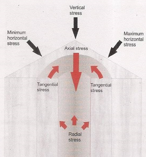
Figure 1: Stresses acting on a wellbore wall (after Kirsch, 1898)
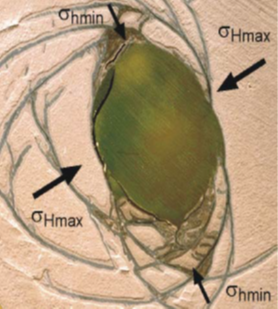
Figure 2: Hollow cylinder lab test simulating of borehole breakout (Tingay et al., 2008.).
Breakout orientations are bimodal, values between 0 – 180ᵒ are similar to those between 180 - 360ᵒ i.e σHmax varies between 0 – 180ᵒ (Reinecker et al., 2003). The average orientation of maximum horizontal stress (Rogers et al., 2008) is determined by calculating the mean breakout angle (θm) using circular statistics (Mardia, 1972). The mean breakout angle of a population of n picked breakout directions, θi is obtained by transforming the angles to the 0 - 360ᵒ interval; θi = 2 θi (Guzman, 2009). Breakout data are ranked based on the World Stress Map quality ranking system (Table 1) (King et al., 2012).
Table 1: The World stress map wellbore breakouts quality ranking criteria (after King et al., 2012, and Adewole and Healy, 2013).
|
Breakout Quality |
No of breakouts |
Breakout lengths |
Standard deviation |
WSM acceptability |
|
A |
Wells with ≥ 10 |
>300 |
≤ 12 |
Acceptable |
|
B |
≥ 6 |
>100 |
≤ 20 |
Acceptable |
|
C |
≥ 4 |
>30 |
≤ 25 |
Acceptable |
|
D |
< 4 |
<30 |
≤ 40 |
Not Acceptable |
|
E |
0 |
0 |
>40 |
Not Acceptable |
2. STUDY AREA
2.1. Location and Geologic Setting
The study area is a coastal swamp oilfield located onshore Niger delta basin and georeferenced N05 13.2208° and E006 41.0107° in Nigeria’s Gulf of Guinea (Figure 3). It is one of the largest regressive deltas estimated to cover an area of 300,000 km2 with a sediment volume of 500,000km3 (Hospers, 1965) and a sediment thickness of over 10km in the basin depocenter (Onojake et al., 2015; Kaplan et al., 1994). A southwestward progradation during basin evolution formed depobelts that represent the most active portions of the delta (Harry et al., 2019) at each stage of its evolution (Doust and Omatsola, 1990; Kulke, 1995). Estimates of recoverable hydrocarbons are about 34.5 billion barrels of oil and 93.8 trillion cubic feet (Tutle et al., 1999) of gas (14.9 billion barrels of oil equivalent) per unit volume of basin-fill (Oni et al., 2014). The stratigraphic sequences of the basin are subdivided into three units namely Akata, Agbada and Benin Formations each of which range from Tertiary to Recent (Short and Stauble, 1967). The onshore portion of the Niger Delta Province is delineated (Turtle et al., 1999) by the geology of southern Nigeria and southwestern Cameroon. The Benin flank, an East-North East trending hinge line south of the West Africa basement massif marks the boundary towards the northwest while Cretaceous outcrops of the Abakaliki High form the northeastern boundary. The Calabar flank, a hinge line bordering the (Onojake et al., 2015) adjacent Precambrian, forms the East-South-East limit of the basin. Offshore, the basin is bounded by the Cameroon volcanic line (Adebayo et al., 2016) to the east, the eastern boundary of the Dahomey basin (the eastern-most (Tutle et al., 1999; Okiwelu and Ude, 2012) West African transform-fault passive margin) to the west, and the two-kilometer sediment thickness contour or the 4000m bathymetric contour in areas where sediment thickness is greater than two kilometers to the south and southwest. This forms the geologic extent of the Tertiary Niger Delta (Akata-Agbada) Petroleum System.
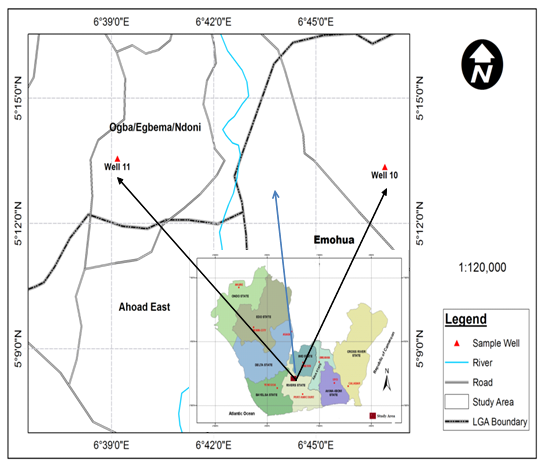
Figure 3: Map of study area showing studied wells (inset map of the Niger Delta).
2.2. Geotectonic Setting
Tectonically, Cretaceous fracture zones during the triple junction rifting and opening of the south Atlantic controlled basin evolution and the palaeo-indicators include trenches and ridges in the deep Atlantic. These fracture zone ridges subdivide the margin into individual basins and forms the boundary faults of the Cretaceous Benue - Abakaliki trough that cuts far into the West African shield (Adewoye et al., 2015). The Benue trough, an aulacogen of the triple junction rift system started opening in the Late Jurassic and persisted into the Middle Cretaceous (Dim 2017; Lehner and De Ruiter, 1977) and diminished in the Niger delta in the Late Cretaceous. This was followed by gravity tectonism as the primary deformational process after cessation of rifting and induced deformation in response to shale mobility (Kulke, 1995).
Shale diapirism due to loading of poorly compacted, over-pressured, prodeltaic and delta-slope clays resulted in the deposition of the Akata Formation, the continental intercalaire (Abija, 2019; Tse and Ogunyemi, 2016) by the higher density delta-front sands of the Agbada Formation (Bakare, 2006). This was followed by slope instability caused by lack of lateral basinward support for the under-compacted delta slope clays of the Akata Formation (Oluwatoyin, 2016). Gravity tectonics indexed by structures such as shale diapirs, roll-over anticlines, collapsed growth fault crests, back-to-back features, and steeply dipping closely spaced flank faults (Oluchukwu, 2016; Dim, 2017) completed the pro-deltaic deposition before deposition of the Benin Formation (Adewoye et al., 2015).
These faults mostly offset different parts of the Agbada Formation and flatten into detachment planes near the top of the Akata Formation. Deposition of the Formations in offlapping siliciclastic sedimentation cycles 30-60Km wide, prograde southwestward 250Km over oceanic crust into the Gulf of Guinea (Adewoye et al., 2015) and synsedimentary faulting occurred in response to variable rates of subsidence and sediment supply (Doust and Omatsola, 1990). Subsidence and supply rates interplay resulted in deposition of discrete depobelts. When further crustal subsidence could no longer be accommodated, the centre of sediment deposition shifted seaward forming new depobelt each marking a break in regional dip of the delta bounded landward by growth faults and seaward by large counter regional faults or the growth fault of the next seaward belt (Evamy et al, 1978; Doust and Omatsola, 1990). Each depobelt is a separate unit recognized by its own sedimentation, deformation, and petroleum history. Doust and Omatsola, (1990) describe three depobelt provinces based on structure. The northern delta province which overlies relatively shallow basement has the oldest growth faults that are generally rotational, evenly spaced with increase steepness seaward. The central delta province has depobelts with well-defined structures such as successively deeper rollover crests that shift seaward for any given growth fault. The distal delta province is the most structurally complex due to internal gravity tectonics on the modern continental slope.
The materials used include density, sonic, resistivity, gamma ray and 4-arm dipmeter logs provided by Total E&P Nig. Ltd and secured through the Department of Petroleum Resources, (DPR), Port Harcourt, Nigeria.
Kinematic reconstruction was achieved by plotting wireline logs against true vertical depth subsea in petrel 2012 software and correlating the stratigraphic units across three wells (5, 10 and 11) in the field using balanced cross-section. Method applies structural and stratigraphic representation of vertical slices through the earth. Geomechanical horizons were identified after choosing a datum. Correlation of the horizons across the three wells which were appropriately located using the well coordinates and tying units to each other using the gamma ray and resistivity logs. Fault surfaces were mapped measuring the fault dip, displacement and thickness of the beds. Fault growth index was calculated based on the ratio of the thickness of the stratigraphic units on the downthrown block to that of the upthrown block.
Wellbore breakouts were analyzed for the orientation of the in situ horizontal stresses using high resolution 4-arm caliper logs data available in two wells, 10 and 11. Study limitation was the non-availability of dipmeter data for stress orientation analysis in well 5. The method of analysis follows the criteria proposed by Plumb and Hickman, (1985); Reinecker et al, (2003); Gough and Bell, (1982) in order to isolate wellbore breakout from other non-stress induced wellbore enlargements such as keyseats and washouts. A wellbore is said to be in gauge when the drill bit fits into the wellbore diameter from top to bottom. Wellbore breakout data were analyzed based on statistical equations (1) to (7) (Mardia, 1972) and data ranked after the world stress map breakout quality ranking system presented in Table 1
(Sperner et al., 2003).
C = 1/n ΣCos θ, ……..…… (1)
S =1/n ΣSin θi ……….…..… (2)
For length weighted mean,
L = Σli , C = 1/nΣli Cos θi, …. (3)
S = 1/nΣ li Sinθi ……..………. (4)
where li = breakout length and θi = breakout angle.
The mean breakout azimuth (θm) is
θm = ½ arctan(S/C). ……….……. (5)
The standard deviation is calculated from the formula below;
So = 360/2π(-1/2logeR)1/2, .. (5)
where R = (C2 + S2)1/2 … (7)
4.1. Well Correlation and Kinematic Restoration
Cross well correlation from datum set at 2400m to a depth of 4,250m total vertical depth subsea (TVDSS) depicts well 11 on the east to have 52 intervening units of sandstone and shales while well 10 on the west revealed 47 stratigraphic units. Well 5 which is located on the downthrown fault block that formed the downwarped grabben indicated 31 stratigraphic units from the correlatable datum which corresponds to 2,580m TVDSS. Two flank faults trending NE – SW and NW – SE were determined. Fault dip angles measured on eight horizons vary from 330 – 460 with an average of 39.50 on east while the west flank’s NW – SE trending fault depicted horizon dip angles ranging from 200 - 440 and average of 35.80. The growth indices of these flank faults vary from 0.7 – 3.0 and mean of 1.28 and 0.4 – 1.9 with a mean of 1.34 on the east and west respectively (Table 2 and Figure 4).
4.2 Present day stress orientation
Analysis of wellbore breakout data in well 10 indicates that compressive wellbore shear failure occurs in a total log length of 2,060.4m where borehole deviation angle varies from 0.70 – 3.70 in a depth interval of 2052 – 3719.4m. The wellbore breakout length ranges from 0.5m – 3.37m and breakout azimuth ranges from 630 – 70.290.
The mean wellbore breakout orientation was 15.890 with a standard deviation of 0.59 and ranked A on the World Stress Map (WSM) ranking system (Bell and Gough, 1979; King et al., 2012; Adewole and Healy, 2013).
In well 11, breakouts were identified in a depth interval of 3991m – 4054.6m where borehole deviation angle varies from 0.40 – 1.80. The total log length analyzed was of 137.9m and breakout length varies 0.5 – 16.8m. The breakout azimuth ranges from 630 – 70.290 with a mean of 33.310, and standard deviation of 9.72, ranked B on the WSM system. Statistical data analysis of wellbore breakout using the method of Mardia, (1972) shows the present-day minimum horizontal stress was 15.890 in well 10 and 33.310 in well 11. The orientation of the present day maximum horizontal stress was 1030 and 1230 in wells 10 and 11 respectively (Table 3 and Figure 5).
5.1. Kinematic Reconstruction
The field’s present day architecture (Figure 4) reveals a tectonically deformed structure. Deformation has been influenced by mechanical heterogeneity, rock mineralogy, porosity, depth of burial, pore pressure and effective stress. The paleotectonic stresses and mechanism of deformation through geologic time show a brittle, rigid body translation with negligible internal distortion. Past tectonic stress fingerprints in the field are indexed by NE – SW and NW – SE dip-slip, listric normal faults which gravity tectonics, facilitated by the generation of overpressures in the high elasticity ductile shales, compaction disequilibrium, centroid and aquathermal effects at greater depths caused the formations to spread out laterally and changing the azimuth of the fault plane into growth faults and roll over anticlines (Abija, 2019).
These faults trend in the same direction as the orientations of the triple junction fracture zones that separated Africa from South America. The fractures extend into Nigeria’s basement complex, the NE – SW zone terminating as a failed rift of the Benue - Abakaliki trough. Rapid progradation of cyclic offlapping sequences of siliciclastic materials resulted in lateral facies intertonguing and thinning out of stratigraphic units.
These sequences have been assigned Oligocene to Miocene age by Baulac et al., (1986) based on distribution of diagnostic Foraminifera and Ostracoda in the core samples such as Globigerina cf acostaensis, Globigerina sacculifer, Eponidopsis eschira, Miogypsinoides sp, Uvigerina peregrine, Eponidopsis umbonatus multispectus – Nonion centrosulcatum bulloides, and Lenticulina sp.
Syndepositional tectonics induced tensile microfracturing and subsequent faulting is believed to have occurred during the Pliocene epoch (exact time yet to be corroborated from seismic data) along the NE – SW and NW – SE directions, axes synonymous with those of the fracture zones that formed the major lines of weakness in the Gulf of Guinea.
The relics of brittle deformation indicate two tectonic episodes; the Aptian/Albian rifting and epeirogenic movement, and the post Miocene faulting. These faults postdate and are younger than the separation of South America from Africa during the triple junction rifting of the Gulf of Guinea into Nigeria.
Increased depth of burial and effective vertical stress favoured syndepositional compaction along the faults axes. This culminates in kinematic translation and downwarping of the downthrown block forming a grabben. The azimuth of these faults flattens out laterally at depth in a plastic deformation response under gravity tectonics (Abija, 2019) as reported in the basin wide delta scenario (Stacher, 1995). The juxtaposition of the faults under a normal stress regime (σv> σHmax > σhmin) occurred on the flanks of the subsiding depocentre and compartmentalization of the sedimentary sequences.
Synkinematic progradation of rapid, intercalating sequences of sandstone and shales were occasioned by marine incursion. The flanking NE – SW and NW – SE trending listric faults are interpreted to be fingerprints of the orientations of the maximum horizontal tectonic stresses which align in the same direction as the triple junction rift system that opened the Gulf of Guinea and separated South America from Africa. Post faulting deposition persisted with accumulation of the overlying continental sandstone of the Benin Formation.
It has been reported that NE-SW, NW-SE, and ENE – WSW trending fault orientations parallel to the Romanche, Chain and Charcot and Ascencion fracture zones of the equatorial Atlantic Ocean (Wright, 1978, Obiosio, 2013) are the regional fault orientations in the Niger Delta (Abija and Tse, 2016b) and constitute arms of the triple junction rift system (Bakare, 2006) that cut open the South Atlantic into the Gulf of Guinea, extending into and terminating as an aulacogen of the Benue-Abakaliki trough (Petters, 1980; Burke et al., 1972; Nwachikwu, 1972). These fracture zones have been suggested as the major lines of weaknesses separating the North and South Atlantic.
The NE-SW trend is consistent with the chain link fracture zone particularly the Ifewara – Zungeru complex fault system (Figure 6) that cuts across the metamorphic basement complex and the younger sedimentary rocks of Nigeria (Adewole and Healy, 2013). The NW – SE fault line is consistent with the Ascension fracture zone that extends into the continent.
5.2. Horizontal Stresses Orientation
Mean wellbore breakout orientations in wells 11 and 10 of N15.89°E and N33.31°E respectively (Table 3 and Figures 5a and b) depict the orientation of the present day minimum horizontal principal stress. Other breakout orientations such as ENE – WSW, NNW – SSW, NW – SE, NE - SW and WNW – ESE orientations suggest multiple sources of stress (Hillis et al., 2008) in the basin. The present day maximum horizontal stress azimuth ranges from N105E° - N123°E.
The dominant present day stress orientations of ENE – WSW, NE – SW and NW - SE (Figures 5a and b) are consistent with the paleostress orientations during the tectonic opening of the Gulf of Guinea, the Oligocene-Miocene deformation and are parallel to the fracture zones that constitute the major lines of weaknesses separating the North and South Atlantic (Wright, 1978).
Multiple sources of stress inconsistent with the regional trend have been attributed to mechanical heterogeneity, structural differences and geologic structures (Bell, 1996).
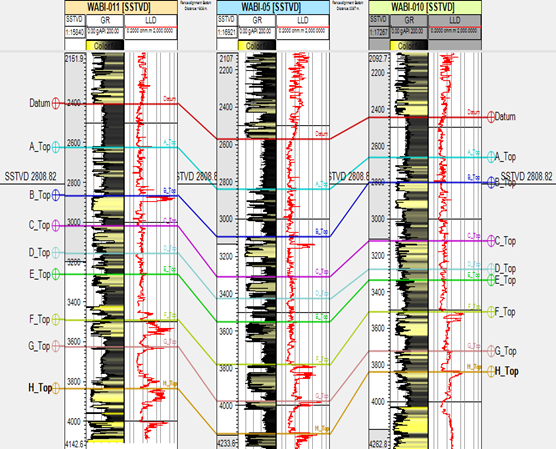
Figure 4: Well correlation showing field architecture with NE- SW and NW – SE flank faults
Table 2: Field Cross section parameters
|
Horizon |
Horizon thickness (m) |
East Wall Growth index |
Horizon dip (deg) |
West wall Growth index |
Horizon dip (deg) |
||
|
East Wall Upthrown block (Well 11) (m) |
Downthrown Well 5 (m) |
West Upthrown block Well 10 |
|||||
|
Datum |
200 |
260 |
220 |
1.3 |
33 |
1.2 |
20 |
|
A |
260 |
260 |
140 |
1 |
36 |
1.9 |
30 |
|
B |
140 |
140 |
320 |
1.6 |
37 |
0.4 |
44 |
|
C |
140 |
140 |
160 |
0.7 |
40 |
1.7 |
32 |
|
D |
100 |
100 |
60 |
1 |
40 |
1.7 |
27 |
|
E |
220 |
220 |
200 |
0.8 |
41 |
0.9 |
36 |
|
F |
340 |
340 |
180 |
0.8 |
39 |
1.4 |
44 |
|
G |
60 |
60 |
120 |
3 |
44 |
1.5 |
41 |
|
H |
|
|
|
- |
46 |
- |
48 |
|
Range |
|
|
|
0.7 – 3.0 |
33 - 46 |
0.4 – 1.9 |
20 -48 |
|
Average |
|
|
|
1.28 |
39.5 |
1.34 |
35.8 |
The in situ maximum horizontal stress direction is corroborated by faulting and paleostress trends which were a result of tensional and shear stresses that extended into the African continent in Nigeria’s Niger Delta and terminating as a failed rift in the Benue – Abakaliki trough during the cretaceous (Wright, 1978).
Faults and fractures in the earth whether natural or induced, strike in the direction of the maximum horizontal stress, perpendicular to the minimum principal stress orientation (Keim, 1999). This, Hubbert and Willis, (1957) demonstrated from their experiment on hydraulically stimulated fractures. They concluded that hydraulic fractures in the earth always propagate perpendicular to the minimum horizontal principal stress (σhmin) (Zoback et al., 2003) direction since it is the least energy configuration parallel to maximum horizontal principal stress.
This implies that the orientation of the two faults parallel to the two maximum horizontal stress directions of the paleostress field are consistent with the NE-SW and NW-SE arms of the triple junction rift system that rifted open the South Atlantic into the Gulf of Guinea in Aptian/Albian age. The tectonic activities were dominantly crustal stretching and fracturing induced by tensile stress magnitude high enough to overcome the yield strength of the subcrustal lithosphere. This process rifted open the continent followed by shear displacement of the blocks relative to the orientations of the major principal stresses and producing epeirogenic movements that created downwarps as depocentres. The magnitude of the present day stresses (Abija and Tse, 2016b), are in agreement with the Andersonian normal fault stress regime (Anderson, 1951).
5.3. Implications for Tectonic Reactivation in Nigeria
The NE – SW, NW – SE, ENE – WSW dominant present day maximum horizontal stress orientations in the Niger Delta field are consistent with the paleostress regime of the Aptian/Albian and Oligocene - Miocene ages. Tectonically, the orientations indicate that tectonic plate driving stresses during the Aptian/Albian rifting of the Gulf of Guinea and separation of South America from Africa; the Oligocene – Miocene faulting, and the present day intra plate stress orientations all align in the same directions.
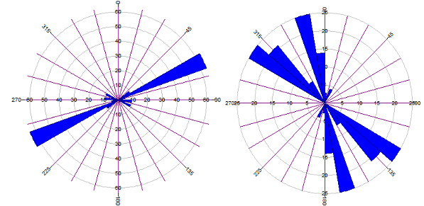
Figure 5: Horizontal stress direction Rossettes (a): Well 11 (b) Well 10
The magnitudes of the present day stresses though yet to attain magnitudes significant enough to overcome the yield strength of the crustal lithosphere and create large scale rifting, but are generating earth tremors across the country. Adewole and Healy, (2013) have suggested that repeated earth tremors in the Niger Delta are the effects of continental crust reactivation linking the onshore faults along major lineaments. These extend into the basement complex region of Nigeria.
Abraham et al., (2014) attributed earth tremors in the coastal areas of Nigeria to their close proximity to the boundary between the African plate and South American plate. Eze et al., (2011) believe these tremors could have been possibly initiated by the processes of present day plate movements and the resulting tectonic stresses. The stresses built up around plate boundaries could travel toward the centre of the plate triggering intraplate tremors especially along pre-existing faults (Eze et al., (2011).
Recently, there have been repeated occurrences of earth tremors in different parts of Nigeria (figure 8), clearly indicating the release of present day intra plate tectonic stress and continental reactivation which is generating the seismic activities across the continental basement. Afegbua et al., (2011) reported on these seismic events to include Warri – Ijebu Remo, Yola – Damba, Akka – Jushi seismic line systems suggesting their origin from regional stresses from the West African craton as reported by Adepelumi et al., (2008). Further reasons adduced for these tremors include subsurface heterogeneities and lines of weaknesses created by magmatic intrusion and a NE – SW trending fault line originating from the S/Atlantic to the Ijebu Remo – Ibadan axis inferring the Ifewara – Zungeru fracture zone system. Long term intra crustal deformations may be related to local and regional tectonic events and plate boundary movements can propagate tectonic stresses within the earth’s crust over thousands of kilometers. These crustal deformations are capable of triggering rifting, folding and rates of subsidence of sedimentary basins even in remote distance regions (Gaina et al., 2013).
The shapes of Nigeria’s Benue Trough and the Cameroon hingeline have been linked by (Fitton, 1980) who suggested their possible origin from a triple junction hot zone in the asthenosphere over which the African plate moved. Gaina et al (2013) in their reconstruction of the history of accretion and subduction of the African plate recognized an intra-continental plate boundary running from North Africa precisely between the NW and NE Africa through the Tenere basin down to the Benue trough, Nigeria which is releasing intra plate tectonic stress and generating tremors in the dominant direction of the NW – SE.
Table 3: Wellbore breakout data.
|
Break out top (TVDSS) (m). |
Break out bottom (TVDSS) (m) |
Breakout length (m) |
Log length analyze (m) |
Hole deviation (°). |
Breakout Azimuth (°) |
Mean Breakout Azimuth (°) |
Standard deviation |
WSM ranking |
σhmin direction |
σHmax direction |
|||||||
|
WELL 10 |
|
|
|||||||||||||||
|
2052.7 |
2054.7 |
2 |
2,060.4 |
0.80 |
26 |
15.89 |
0.59 |
A |
015ᵒ |
105ᵒ |
|||||||
|
2070.7 |
2089.2 |
18.2 |
0.70 |
4.75 |
|||||||||||||
|
2350.6 |
2351.1 |
0.5 |
2.7 |
22.5 |
|||||||||||||
|
2359.2 |
2360.3 |
1.1 |
2.4 |
22.5 |
|||||||||||||
|
2874.3 |
2886.5 |
12.2 |
0.73 |
13.70 |
|||||||||||||
|
2902.3 |
2903.5 |
1.2 |
0.75 |
12 |
|||||||||||||
|
3082.8 |
3083.9 |
1.1 |
1.0 |
48 |
|||||||||||||
|
3134.9 |
3135.4 |
0.5 |
1.4 |
18 |
|||||||||||||
|
3312.5 |
3313.2 |
0.7 |
1.3 |
35 |
|||||||||||||
|
3454.2 |
358.5 |
4.3 |
2.9 |
55.5 |
|||||||||||||
|
3463.3 |
3464.1 |
0.8 |
3.0 |
57 |
|||||||||||||
|
3555.3 |
363.9 |
8.6 |
3.09 |
53.8 |
|||||||||||||
|
3586. |
3586.8 |
0.8 |
2.9 |
51 |
|||||||||||||
|
3675.7 |
3689.4 |
13.7 |
3.37 |
47.5 |
|||||||||||||
|
3719.4 |
3722.9 |
3.5 |
3.22 |
38.25 |
|||||||||||||
|
WELL 11 |
|||||||||||||||||
|
3991.4 |
3998.2 |
6.8 |
137.9 |
0.52 |
70.29 |
33.31 |
9.72 |
B |
033ᵒ |
123ᵒ |
|||||||
|
4000.5 |
4001. |
0.5 |
0.4 |
63 |
|||||||||||||
|
4004.8 |
4021.6 |
16.8 |
1.45 |
69 |
|||||||||||||
|
4041.9 |
4042.7 |
0.8 |
1.8 |
64 |
|||||||||||||
|
4053.6 |
4054.6 |
1 |
1.7 |
64 |
|||||||||||||
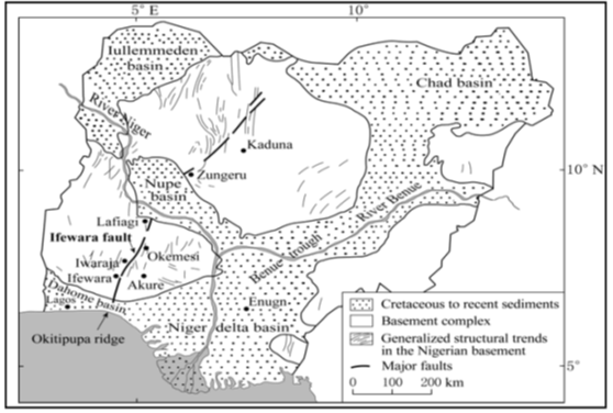
Figure 6: Map of Nigeria showing the Zungeru - Ifewara fault (Afegbua, 2011)
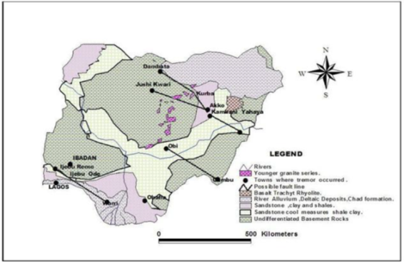
Figure 7: Geological Map of Nigeria Showing Locations of Earth Tremor (Eze et al., 2011).
The rate of migration of the African tectonic plate has been predicted to be 2.15cm/year (Huang, 1997) in a general NE – direction towards the Eurasian plate. This movement generates intra-plate and plate boundary stresses that are inducing reactivation of the continental crust following the major fracture zones. In Nigeria, the NE – SW, NW – SE and minor ENE – WSW orientations of two episodes of rifting (Aptian/Albian and Oligocene - Miocene) and the present day stresses together with the concentration of repeated earth tremors along these lines of orientations as revealed in the Warri – Ijebu Remo – Ibadan and Yola – Damba – Abuja areas consistent with the stress orientations, indicates that the continental crust is reactivating along the pre-Aptian/Albian fracture zones into the basement complex.
The geodynamic response to stress which often result in brittle deformation and syndepositional block kinematics create sedimentation basins and fluid flow trapping mechanisms. Kinematic restoration depicts two normal faults at the flanks forming a grabben. These faults developed into growth faults at greater depths with growth indices averaging 1.38 and 1.24 on west and east respectively. The faults’ orientations are parallel to directions of the maximum horizontal principal stress which average rang from N105°E - N123°E and perpendicular to the minor principal stress which average magnitude ranges from 015° - 033°.
The stratigraphic section is characteristic offlapping cyclic sedimentation sequences of siliciclastic materials deposited in the middle to outer neritic environment during the Oligocene – late Miocene epoch. Paleo and in situ stress orientations are consistent with the orientations of the major fracture zones in the Gulf of Guinea along which the triple junction rifting into Nigeria’s Benue trough had occurred. Recent increase in the number of earth tremors in Nigeria occurring in the NE – SW, NW – SE and ENE – WSW trends have been correlated with the two tectonic episodes, the Aptian/Albian epeirogenic tectonism, the late Miocene – Pliocene faulting deformation together with the present-day stress orientations and multiple earth tremors in Nigeria, all align in the axes of the major fracture zones that separated South America from Africa indicating that intraplate tectonic reactivation along the major fracture zones that cut into Nigeria’s basement complex is imminent
The author wishes to express his profound gratitude to Total Exploration and Production Nigeria Ltd and the Department of petroleum Resources, Port Harcourt, Nigeria for providing data for this research.
Abija, F. A. (2019). Geomechanical property evolution and the mechanics of growth faulting in a Niger Delta Oilfield, Nigeria. International J. of Geology and Earth Sciences, Vol. 5, No. 2 pp. 73 - 95.
Abija, F. A. and Tse, A. C. (2016a). Geomechanical evaluation of an onshore oilfield in the Niger Delta, Nigeria. IOSR J. Applied Geology and Geophysics, Vol. 4, Issue 1, Version 1, Pp. 99 - 111.
Abija, F. A. and Tse, A. C. (2016b).In situ stress magnitude and orientation in an onshore field, Eastern Niger Delta: implications for directional drilling, SPE 184234-MS Pp. 1 -15.
View ArticleAbraham, E. M., Lawal, K. M., Ekwe, A. C., Alile, O., Murana, K. A. Lawal, A. M. (2014). Spectral analysis of aeromagnetic data for geothermal energy investigation of Ikogosi warm spring - Ekiti State, South western, Nigeria. Geothrmal Energy, 2(6). PP.1 - 21.
View ArticleAdepelumi, A.A. Ako,, B.D., Ajayi, T.R., Olorunfemi, A.O. Awoyemi, M.O. and Falebita, D.E.(2008). "Integrated Geophysical Mapping of the Ifewara Transcurrent Fault System, Nigeria". Journal of African Earth Sciences. 52(4-5), 161-166.
View ArticleAdewole, E. O. and Healy, D. 2013. Quantifying in situ horizontal stress in the Niger delta basin, Nigeria, GSTF J. of Engineering Technology (JET) Vol. 2, No. 3.
View ArticleAfegbua K.U, Yakubu, T. A, Akpan O U, Duncan D and Usifoh E. S. (2011). "Towards an Integrated Seismic Hazard Monitoring in Nigeria using Geophysical and Geodetic Techniques". International Journal of the Physical Sciences Vol. 6(28), pp. 6385-6393, 9.
View ArticleAhamefula, U, U., Odoh, B. I., Amogu, D.K., Ekwe, A. C., Egboka, B. C.E (2013). Characterization of near surface fractures for hydrogeological studies using azimuthal resistivity survey: A case history from the Mamu Formation, Enugu (Nigeria). Environmental Geosciences, 20(2) pp.1- 16. Doi: 10.1306/eg/11281212009
View ArticleAllan, V. S. (1989). Model for Hydrocarbon migration and entrapment within faulted structures. AAPG Bulletin Vol. 73, 803 - 811.
View ArticleAl-Ajimi, H. (2013). Sedimentology, Stratigraphy, and reservoir quality of the Paleozoic Wajid sandstone, in SW Saudi Arabia. PhD thesis, Technische Universitat Darmstadt. 134pages.
Ali, A. H. A, Brown, T, Delgado, R., Lee, D., Plumb, D., Smirnov, N., Marsden, R., Prado-Verlado, E., Ramsey, L., Spooner, D., Stone, T., Stouffer, T. 2003. Watching rocks change - Mechanical Earth Modeling. Oil Review - Summer, Pp. 22 - 39.
Allison, D. T. (2015). Structural Geology Laboratory Manual.4th Edn. Department of Earth Sciences, University of South Alabama. 205pages.
Amadei, B. and Stephansson, O. (1997). Rock stress and its measurement. London: Chapman and Hall. 490pages.
View ArticleAmogu, D.K., Ekwe, A. C. and Onuoha, K. M.(2010). Kinematics of faults and joints at Enugu area of the Anambra basin. J. of Geology and Mining Research, Vol. 2 (5) pp. 101 - 113.
Anderson, E.M. 1951. The Dynamics of Faulting and Dyke Formation with Applications to Britain. Edinburgh, UK: Oliver and Boyd.
Babcock, E. A. (1978). Measurement of subsurface fractures from dipmeter logs. AAPG Bull. Vol. 62, (7) pp. 11 - 1126.
View ArticleBakare, O. (2006). Effects of growing structures on stratigraphic evolution channel architecture and submarine fan distribution Niger delta, West Africa. M.S. dissertation, Colorado School of Mines, IL, USA.
Banerjee, S. and Muhuri, S. 2013. Applications of geomechanics: based restoration in structural analysis along passive margin Settings, deep water Niger Delta example. In New Understanding of the petroleum system of continental margins of the world. PMid:22407934
View Article PubMed/NCBIBaulac, J., Grosdidier, E. and Boutet, C. (1986). Wabi 10 biostratigraphy, (2015-4504 m). S. N. E. A. (P) Direction Exploration Report, Elf Petroleum Nigeria Limited /Geosciences, 13pages.
Bell, J.S. 1996. In situ stresses in sedimentary rocks (part 1): Measurement techniques. Geoscience Canada, Vol. 23, 85 - 100.
Bell, J. S. and Gough, D. I. (1979). Northeast-southwest compressive stress in Alberta. Evidence from oil wells. Earth and Planetary science Letters, 45, pp. 475 - 482. 90146-8
View ArticleBoak, J. M (1993). Geological cross sections: methods in exploration No 10. Geological methods.
View ArticleBurke, K., Dessauvagie, T. F. G., and Whiteman, A. J. (1972). Geological history of the Benue valley and adjacent areas. In Dessauvagie, T. F. G., and Whiteman, A. J. eds. African Geology, Ibadan University Press, Ibadan, pp 87 - 205.
Cook J, Rene, A.F, Hasbo, K, Green, S., Judzis A., Martiu, J. W, Suarez-Rivera, R, Jorg, H, Hooyman, P., Lee, D, Noerth, S, Sayers, C, Koutsabelloulis, N, Marsden R, Stage, M. G and Tan, C. P. 2007. Rocks Matter: Ground Truth in Geomechanics. Oil Review, Pp 36 - 55.
Cornet, F. H., Berard, Th. and Bourouis, S. (2007). How close to failure is a granite rock mass at a 5km depth? Int. J. of Rock mechanics and Mining Sciences, 44(1), pp. 47 - 66. Doi:10.1016/ijrmms2006.04.008
View ArticleCoulomb, C. A. (1773). Sur une application des regiles de maxims et minimis a quelqus problemes de stratique reglatifs a l"architectie. Acad. Roy. Sci. Memde. Phys., 7, 343 - 382.
Dim, C., I. P. (2017). Hydrocarbon prospectivity in the Eastern coastal swamp depo-belt of the Niger delta basin, Springer briefs in Earth Sciences, doi:10.1007/978-3-319-44627-1_2
View ArticleDoust, H., and Omatsola, E., 1990, Niger Delta, in, Edwards, J. D., and Santogrossi, P.A., eds., Divergent/passive Margin Basins, AAPG Memoir 48: Tulsa, AAPG, Pp. 239-248.
Dutta, D., Juandi, D., and El Fotoh, A. A. (2009). In situ stress pattern and its impact in drilling high angle wells in the Gulf of Suez, Egypt. SPE 122478-MS. Doi:10.2118/122378-MS.pp. 1 - 10.
View ArticleEvamy, B.D., Haremboure, J., Kamerling, P., Knaap, W.A., Molloy, F.A., and Rowlands, P.H. 1978. Hydrocarbon habitat of Tertiary Niger Delta: AAPG Bull., Vol. 62, Pp. 277-298.
View ArticleEze, C.L., Sunday, V.N Ugwu, S.A Uko, E.D and Ngah, S.A (2011) "Mechanical Model for Nigerian Inter -plate earth Tremors."
View ArticleFitton J. G. (1980). The Benue trough and Cameroon line: A Migrating rift System in West Africa. Earth and Planetary Science Letters, 51 (1980) 132-138. 90261-7
View ArticleFossen, H. (2010). Structural Geology. Cambridge:Cambridge University Press.
View ArticleGaina, C., Torsvi, T. H., van Hinsbergen, D. J.J., Medvedev, S., Werner, S. C., Labails, C. (2013). The African Plate: A history of oceanic crust accretion and subduction since the Jurassic. Tectonophysics, 604, pp.. 4 - 25.
View ArticleGough, D.I. and Bell, J.S. 1982. Stress Orientations from Borehole Wall Fractures with Examples from Colorado, East Texas, and Northern Canada. Can. J. Earth Sci. 19: Pp.1958-1970.
View ArticleGuzman, C. G. and Cristallini, E. (2009). Contemporary stress orientations from borehole breakout analysis in the southernmost flat slab boundary. Andean retroarc C320 44'and 330 40'S . J. of Geophy. Res., Vol. 114 XXXXXX, doi:10.1029/2007JB005505, 2009.
View ArticleHarry, T. A., Osung, W., Ibanga, I., Enidiok, M. (2019). Paleoclimatic changes and palynocycles of the late tertiary Niger Delta, southern Nigeria. Int. J. of Scientific and engineering res. Vol. 10 Issue 3, pp. 1 - 12.
Hillis, R. R., Sandiford, M. Reynolds, S.C., and Quigley, M. C. (2008). Present-day stresses, seismicity, and Neogene to Recent tectonics of Australia's passive margins: intraplate deformation controlled by plate boundary forces. Geological Survey of London Special Publication. 306, 71 - 89.doi:10.1144/SP306.3
View ArticleHospers, J., 1965, Gravity field and structure of the Niger Delta, Nigeria, West Africa: Geological Society of American Bulletin, Vol. 76, p. 407-422. 76[407:GFASOT]2.0.CO;2
View ArticleHuang, Z.S. (1997). Speed of the continent. The Physics Fact book. Retrieved 7 June, 2018.
Hubbert M.K. and Willis, D.G. (1957). Mechanics of hydraulic fracturing. Pet. Trans AIME: 210, Pp.153 - 263.
Hudson, J. A and Harrison, J.P. 1997. Engineering rock mechanics - An introduction to the principles. Amsterdam.
View ArticleJaeger, J. C. and Cook, N. G. W. (1979). Fundamentals of Rock Mechanics 3rd edn. New York: Chapman and Hall 515pages.
Kaplan, A., Lusser, C.U., Norton, I.O. 1994. Tectonic map of the world, panel 10: Tulsa, American Association of Petroleum Geologists, scale 1:10,000,000.
Keim, S. K. and Miller, M. S. (1999). Case study evaluation of geological influences impacting mining conditions at a West Virginia longwall mine. Int. Journal of Coal Geology, 41 (1): 51 - 71 00011-7
View ArticleKing, R., Backe, G, Tingay, M. Hillis, and Mildred, S. (2012). Stress deflections around salt diapirs in the Gulf of Mexico. Geological survey of London Special publication, 367, pp. 141 - 153. Doi:10.1144/SP367.10
View ArticleKirsch, G. 1898. Die Theorie der Elastizitat und die Beedurnise der Festigkeitslehre. VDI Z. 42, Pp707.
Knoll, L. (2016). The process of building a mechanical earth model using well data. M.Sc thesis, Department of Petroleum Engineering, Montan Universitat, Austria. 98 pages.
Kulke, H., 1995, Nigeria, in, Kulke, H., ed. Regional Petroleum Geology of the World. Part II: Africa, America, Australia and Antarctica: Berlin, Gebrüder Borntraeger, Pp. 143-172.
Lehner, P., and De Ruiter, P.A.C. 1977. Structural history of Atlantic Margin of Africa: American Association of Petroleum Geologists Bulletin, Vol. 61, Pp. 961-981.
View ArticleLi, Y. (1997). Drilling induced core damages and their relationship to crustal in situ stress states and rock properties. PhD thesis, Department of Physics, University of Alberta, Edmonton, Canada. 247pages.
Mardia, K. V. 1972. Statistics of directional data. New York: Academic press.
McLean, M.R. and Addis, M.A. 1990. Wellbore stability analysis: A review of current methods of analysis and their field applications. Paper IADC/SPE Drilling Conference, Houston, Texas
View ArticleMiddleton, G.V., and Wilcock, P.R., 1996. Mechanics in the Earth and Environmental Sciences. Cambridge University Press, Australia, 496pages.
Mojtaba, R. and Tingay, M. (2016). Pattern and origin of present day tectonic stress in the Australian sedimentary basins. ASEG-PESA-AJG 25th Geophysical conference and exhibition, Adelaide, Australia, extended abstracts. Doi:10.1071/ASEG2016ab275.
View ArticleMoos, D., Peska, P. and Zoback, M. D.(1998). Predicting the stability of Horizontal wells and multilaterals - The role of in situ stress and rock properties. SPE-50386-MS.doi:10.2118/50386-MS. Pp. 1 - 12.
View ArticleMoos, D. and Zoback, M. D.1990. Utilization of observations of well bore failures to constrain the orientation and magnitude of stresses: application to continental deep sea drilling project and ocean drilling program boreholes. J. of Geophysical Research Vol. 95 (B), Pp 9305 - 9325.
View ArticleNelson, E. J. and Hillis, R. R. (2005). In situ stress of the West Tuna area, Grippsland basin. Australian J. of earth Sciences, Vol. 52, pp. 299 - 313.
View ArticleNwachikwu, S. O. (1972). The tectonic evolution of the southern portion of the Benue Trough, Nigeria. Geological Magazine, 109: 411 - 419.
View ArticleObiosio, E. O. (2013). Biostratigraphy and paleoenvironment of Bolivina fauna from the Niger Delta, Nigeria. Earth Sciences Research, Vol 2. No. 2. Doi:10.5539/esr.v2n2p80
View ArticleOni, S.O., Olatunji, A. S., and Ehinola, O. A. (2014). Determination of provenance and tectonic setting in the Niger delta clastic facies using well Y onshore Delta State, Nigeria. J. of Geochemistry, Vol 2014 article ID 960139. 13pages. Doi:10.1155/960139.
View ArticleOkiwelu, A. A. and Ude, I. A. (2012). Chapter 3: 3D Aeromagnetic modeling and basement tectonics of the Niger Delta from aeromagnetic data. Intech pp. 53 - 78. Doi:10.5772/48158. PMid:23135011
View Article PubMed/NCBIOluchukwu, I. C. (2016). Integrated reservoir quality study of "keana"- field, coastal swamp depobelt, Niger Delta. M.Sc. thesis, Dept, of Geology, University of Nigeria, Nsukka., 73pages.
Oluwatoyin, O. (2016). Reservoir evaluation of T-X field, onshore Niger delta from well log petrophysical analysis. Bayero J. of Pure and Applied sciences vol. 9(20 132 - 140.
View ArticleOnojake, M.C., Osuji, L. C. and Abrakasa, S (2015). Source, depositional environment and maturity levels of some crude oils in the southern Niger delta, Nigeria. Chinese J. of Geochemistry, 34(2), 224 -232. doi:10.1007/s11631-015-0035-9
View ArticlePasic, B., Gaurena-Medimurec, N., and Mantanovic, D. 2007. Wellbore instability: Causes and Consequences. Rudarsko-geolosko-naftni-zbornik, Vol. 19, Pp 87 -98.
Paulsen, T., Millan, C.,Pierdominici, S., Wilson, T., Drew, S. and THE Andril-SMS Science Team (2009). Fracture logging of the ANDR-2A Core ANDRIILL, Southern McMurdo Sound Project, Antarctica. Terra Antarctica, 15(1) pp. 69 - 76.
Park, R. G. (1997). Fundamentals of Structural Geology. London: Chapman and hall.
Peska, P. and M. D. Zoback (1995): Compressive and tensile failure of inclined wellbores and determination of in situ and rock strength. - J. Geophysical Research++, 100, 12791-12811.
View ArticlePetrowiki (2016).
View ArticlePetrowiki (2016)
View ArticlePetters, S. W. (1980). Biostraigraphy of the upper cretaceous foraminifera of the Benue Trough, Nigeria. J. Foram. Research, 10:191-204
View ArticlePlumb, R.A. and Hickman, S.H. 1985. Stress-induced borehole elongation: A comparison between the four-arm dipmeter and the borehole televiewer log. In Auburn Geothermal Well. Journal of Geophysical Research, Vol. 90 (B7): Pp 5513 - 5521.
View ArticleReinecker, J., Tingay, M. and Muller B. 2003. Borehole breakout analysis from four arm caliper logs. World Stress Map Project: Guidelines; Four arm caliper logs. Pp. 1 - 5.
Rogers, C. van Ruth, P., J., Hillis, R. (2008). Fault Reactivation in the port Campbell Embayment with respect to CO2 sequestration, Otway basin, Australia. Geological Society of London Special Publication. 306(1), pp. 201-214 doi:10.1144/SP 306.10
View ArticleShort, K. C., and Stäuble, A.J., 1965, Outline of geology of Niger Delta: American Association of Petroleum Geologists Bulletin, Vol. 51, Pp. 761-779.
Sperner, B, Muller B, Heidbach, O, Delvaux, D, Reinecker, D, and Fuchs, K. 2003. Tectonic stress in the earth's crust. Advances in the World stress map project. In Nieuwland, D.(ed). New insights into structural interpretation and modeling, Geological Society of London Special Publication, Vol. 212, Pp.101 - 116.
View ArticleStacher, P. 1995. Present understanding of the Niger Delta hydrocarbon habitat, in, Oti, M.N., and Postma, G., eds., Geology of Deltas: Rotterdam, A.A. Balkema, p. 257-267.
Tingay, M., Reinecker, J. and Muller, B. (2008). Borehole breakout and drilling induced fracture analysis from image logs. Guidelines: image logs. WSM project. Pp 1 - 8.
Tiwari, R. R. 2013. Recognizing horizontal stress orientation for optimizing well placement and well completion jobs. SPG India Kochi: 10th Biennial International Conference and Exposition. Paper No 042 Pp. 1 - 5.
Tse, A. A. and Ogunyemi, A. O. (2016). Geotechnical and chemical evaluation of tropical red soils in a deltaic environments: Implications for road construction. Int. J. of Geology, Earth and Environmental Sciences Vol. 6(1). Pp. 19 - 29.
View ArticleTurner, J. P., Healy, D., Hillis, R. R., and Welch, M.J. (2017). Geomechanics and Geology: Introduction. In Geomechanics and Geology Vol. 458 pp. 7 -29. Geological Society of London special Publication. DOI:10.1144/SP 458.15
View ArticleTurtle, M. L. W., Charpentier, R. R. and Brownfield, M. E. (1999). Chapter A. The Niger delta Petroleum system; Niger Delta province, Nigeria, cameroon and equatorial Guinea, Africa. US Department of Interior, USGS open file report No. 99 - 50-H
View ArticleWright, J. B. 1978. Fracture system in Nigeria and initiation of fracture zones in the South Atlantic. Tectonophysics, Vol. 34, PP 13 - 47. 90093-7
View ArticleZhou, S., Hillis, R. and Sandiford, M. (1994).A study of the design of inclined wellbores with regards to the mechanical stability and fracture intersection and its application to the Australian North West Shelf. J. of Applied Geophysics, 32(4). Pp. 293 - 304. Doi:10.1016/0926-9851(94)90029-9. 90029-9
View ArticleZoback, M. L. (1989). State of stress and modern deformation of the Northern basin and range province. J. of Geophysical research, vol. 94 No. B6 pp.. 7105 - 7128.
View ArticleZoback, M.D., Stephenson, R.A., Cloetingh, S., Larsen, B.T., Vanhoorn, B., Robinson, A., Horvath, F., Puigdefabregas, C., Benavraham, Z., 1993. Stresses in the lithosphere and sedimentary basin formation. Tectonophysics 226, 1-13. 90107-U
View ArticleZoback, M.D, Barton, C. A., Budy, M., Castillo, D. A., Finkbeinerr, T., Grollimund, B. R., Moos, D. B., Peska, P., ward, C. D and Wiprut, D. J 2003. Determination of stress orientation and magnitude in deep wells. International Journal of Rock Mechanics and Mining Sciences. Vol. 40, Pp1049 - 1076.
View Article